
Posted on May 2, 2019
KALAMAZOO, Mich. — The floating excavator in the middle of one of the crosstown ponds will continue to be part of the Vine neighborhood scene through the end of the summer.
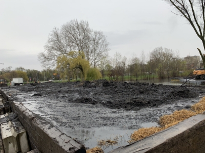
The city of Kalamazoo started dredging the ponds and nearby Axtell Creek in April 2019 as part of a plan to mitigate severe flooding in the area.
“The plan is to remove the sediment and the deposit of organics from the sediment,” said Ryan Stoughton, the assistant civil engineer assigned to the project. “Remove those, so that way it restores the ponds to the original design capacities.”
Along with the removal of sediment from the ponds, the city will clean and inspect the Axtell Creek culverts.
“The dredging is currently scheduled to go through about the first of September and then the cleaning and inspecting of the culverts [is scheduled for] about the August timeline,” Stoughton said.
With rain in the forecast for this week, contractors likely won’t be on site until conditions improve. In anticipation of the rain, barriers were set up to prevent any of the previously dredged material from returning to the ponds. The city’s plan called for the removal of 11,140 cubic yards of sediment. That amount of dirt would fill 1,100 dump trucks.
The dredged sediment “will be dewatered here on site to remove as much of the water to put it back into the creek and send it down to Portage Creek to the Kalamazoo River to Lake Michigan, where Mother Nature ultimately wants it to go,” Stoughton said. “And the dewatered material will be trucked off site to a landfill.”
The dewatering of sediment is the removal of water from solid material or soil by filtration, centrifugation or other solid-liquid separation processes. The process makes the loads lighter when carrying off the unwanted sediment.
The city tested the sediment before dewatering to determine what type of landfill could be used. The results of the tests classified the material as non-contaminant sediment and organic material.
This project is the first in a long-term plan to help with the severe flooding of the area.
“This is one item in a long-term plan, it takes a lot of puzzle pieces to make the whole thing come together,” Stoughton said. “But you have to start somewhere. There is always a jumping off point on any long-term mitigation project .”
Forest Street from Park and Rose Streets is closed for this project and scheduled to reopen after August 30, 2019.
The city of Kalamazoo is currently working with the U.S. Army Corps of Engineers to develop hydraulic modeling and flood inundation mapping for the Kalamazoo River, Portage Creek and Axtell Creek. The goal of this study is to provide real-time flood inundation maps for emergency response as well as to better understand the river dynamics, including flow characteristics and flooding impacts from different scenarios. The model and results of this study might be used in consideration of future floodplain mitigation and emergency management.
Source: wwmt.com


