
Posted on November 19, 2018
Woolwich and the state are looking into ways to revive a saltwater marsh while fixing a tiny bridge along Route 1.
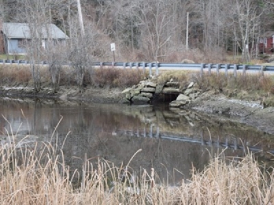
The Kennebec Estuary Land Trust was recently awarded a $250,000 grant to explore the restoration of 140 acres of wetlands at the confluence of the Back River Creek and Pleasant Cove. Northbound motorists on Route 1 see the area after they pass The Taste of Maine Restaurant in Woolwich, where the road dips down into the marsh before rising back up. In the middle of the marsh, Route 1 intersects with George Wright Road.
Restoring the area to a salt marsh would create valuable habitat for fish and wildlife, according to the land trust.
“It would be a great spawning area,” said the trust’s director, Carrie Kinne.
Before Route 1 was built through the marsh, it was an unrestricted tidal salt marsh. After the road bisected the marsh, the wetlands north of Route 1 was cut off from its saltwater source, and over time has taken on freshwater characteristics.
“Now it’s kind of an unhealthy freshwater marsh. It’s not draining well. It’s not in great condition,” said the trust’s project coordinator, Ruth Indrick.
Culverts were installed under both the George Wright Road and Route 1 to allow saltwater to flow in and out of the wetlands, but they aren’t effective enough at allowing saltwater to flow upstream into the 140 acres of wetlands.
“Salt marshes are a great spot for juvenile fish to develop,” added Indrick. In addition to the environmental interests, there are also safety reasons for making changes to the stretch of road. The section of road that cuts through the marsh dips low enough that there is frequent flooding of the road, and the area has seen a number of car crashes in recent years. Both Maine Department of Transportation and the town of Woolwich are considering infrastructure improvements to the area, which could facilitate the restoration of the saltwater marsh.
Woolwich has been looking into repairing or replacing the George Wright Road Bridge after a 2017 Maine DOT inspection found it was in poor condition. The 9-foot bridge was originally built in 1934.
The existing culvert under the George Wright Road Bridge also presents its own safety concern, as massive amounts of water on either side of the bridge is funneled through the narrow hole.
“You’ve got a huge amount of water coming out of here,” Eric Calderwood of Calderwood Engineering told Woolwich selectmen last year. “It really made me concerned that you may wind up in a situation where a kid walking a dog winds up getting sucked into that. It’s got enough force coming out of there and there’s enough debris in there that I think you can trap someone in there and end up drowning them.”
The town hired Calderwood to conduct an evaluation of the bridge last year.
Redesigning that bridge to ensure it is structurally sound while increasing the amount of water flowing underneath it would reduce safety concerns while allowing more saltwater to enter the wetlands north of Route 1. The Woolwich Select Board wrote a letter in support of the land trust’s initiative, as have the Maine Department of Transportation and the Bath Water District, said Indrick.
But redesigning that bridge to allow more flow could have unintended consequences on Route 1. If more water is allowed under George Wright Road, the could put more pressure on the culverts currently underneath Route 1. As the trust looked into the possibilities of restoring Woolwich wetlands, it became increasingly obvious that any solution would have to address George Wright Road, the Bath Water District water main and Route 1.
Route 1 in Woolwich is currently slated for improvements. The Maine Department of Transportation is planning to address structural issues with the bridge leading into the marsh, and are open to making changes to the section crossing the marsh as well. The department has expressed interest in raising that section of the road to prevent flooding, as well as increasing the water flow under the road, which could lead to wetlands restoration.
Over the next 18 months, the project will involve monitoring, hydrologic modeling and engineering plans. The land trust’s role will be as a facilitator, overseeing the study and leading the discussion with other groups involved.
“We don’t know where this is going to end up, but at least it’s a whole conversation,” said Kinne.
Source: The Times Record


