
Posted on October 4, 2018
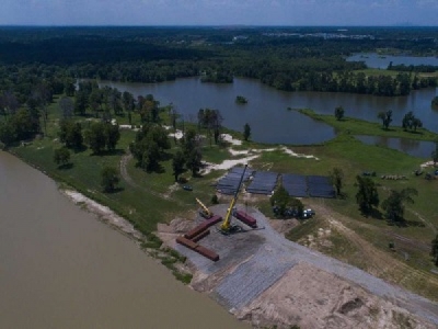
The goal of dredging the San Jacinto River’s West Fork is to return it to its flow and holding capacity to its levels pre-Hurricane Harvey, whose rainwater carried large amounts of sedimentation downstream and deposited it in areas of the West Fork and Lake Houston.
A big question on the minds of Lake Houston area officials and stakeholders is how to bring about more longterm flood remediation for Lake Houston communities.
Recommended Video
“There are a lot of different moving parts of this,” said Mark Mitchell, president of the Lake Houston Area Economic Development Partnership.
With the U.S. Army Corps of Engineers’ dredging project underway, as well as the passage of the Harris County Flood Control District’s $2.5 billion flood bond, remediation efforts do continue to move forward. Numerous entities are collaborating to formulate and implement remediation strategies. Some of these strategies are already in motion, while others are still nebulous concepts.
Working together
The Harvey Recovery Task Force, headed-up by the Lake Houston Area Chamber of Commerce, is a partnership of local stakeholders that meets regularly to push for Lake Houston area flood mitigation.
BIG MONEY: Multi-billion dollar water plant will extract millions of gallons of safe drinking water
“The group has been meeting regularly for the past several months and that’s included the Army Corps, Harris County Flood Control, the San Jacinto River Authority, Harris County, several different corporations and the neighborhood groups that are actively involved in the mitigation and remediation and most importantly education,” Mitchell said.
An example of the education outreach initiatives is the Lake Houston Chamber’s campaign encouraging area residents to vote in the flood bond election. Community residents, such as Bill Fowler, who co-chairs the Lake Houston Area Grassroots Flood Prevention Initiative, point to the disparity of voting results between Harris County as a whole, and the Kingwood area.
“Total county, 85 percent voted for the bond, but only about 7 percent of the eligible voters came out to vote. …Kingwood had 89 percent approval with 17 percent voting. The good thing is we had about three times the average of the county in Kingwood,” Fowler said.
Mitchell said that the area’s heightened voting results was the intention of the voting campaign and that the level of community investment can be used as leverage going forward with potential projects included within the bond referendum.
WATER BILL HIKES: Harris county residents could face higher rates
“What we’re trying to do now is to get as much debris out of Lake Houston and the East and West Forks as we can afford based on both the bond referendum and then how we can leverage those bond funds up into additional state or federal funds,” Mitchell said. “The question is what really happens from a maintenance perspective after that.”
Post-dredging
The Harris County Flood Control District, SJRA and Montgomery County have partnered to conduct an intensive investigation of the entire San Jacinto River Watershed to identify areas of high priority that need to be addressed in the immediate future. The results will be used to formulate strategies on how best to respond to the mitigation and remediation needs not just for the Lake Houston area, but the entire San Jacinto Watershed, according to Mitchell.
“That commissioned investigation is actually going to be moving forward probably within the next 30 to 45 days,” Mitchell said.
Additional concerns
Bob Rehak, Kingwood community leader, began his presentation during a Lake Houston Area Grassroots Flood Prevention Initiative in September, by emphasizing that excessive sedimentation can worsen flooding.
BUSINESS RECOVERY: Lake Houston businesses assessed in post-storm survey
“It blocks rivers and ditches,” Rehak said. “It constricts or slows the flow of water. It reduces the through-put, meaning the water lingers longer in the area, and it forces water up and out of the river faster and further.”
Rehak expressed his concern about a massive sand bar at the mouth of the river, where the West Fork meets Lake Houston.
“At the deepest points in one of the cross sections, the channel is 5 feet deep. …The depth is very, very shallow,” Rehak said.
Rehak said that the river depth before the sand starts to elevate towards the sand bar is about 40 feet below the level of the lake.
“As you go towards that mouth bar, the sediment of the river starts to elevate and eventually reaches about 5 feet above the water. …Water has to go uphill — water doesn’t flow uphill very well. So, what we have here is a dam that’s going to be left at the mouth of the river,” Rehak said.
FLOOD BOND PROJECTS: What is being done first in Houston
Rehak said this mouth bar would have significant impacts to people that flooded.
The Federal Emergency Management Agency is funding the Army Corps’ emergency dredging project. However, Rehak explained, FEMA will only fund dredging to return the river to its condition immediately before Harvey. Due to the presence of a tree on the mouth bar, FEMA determined that dredging the mouth bar would be dredging beyond the identified scope of the project.
“You can only spend FEMA money on remediation for things that happened during Harvey,” Rehak said. “This tree could cost $18 million. … Mobilization and demobilization costs for this (emergency dredging) project are 25 percent of the total costs (which comes to) $18 million. If we finish Phase I of this dredging without coming up with a plan to get the rest of this mouth bar, all that equipment is going to leave this river and we’re going to have to mobilize and demobilize a second time and we’ll lose that $18 million.”
Removing the mouth bar
The solution, Rehak said, is to organize a new mouth bar project, or an add-on project by April 1, 2019, which is when the Phase I dredging is projected to be completed.
BACK TO BASICS: Harris County to begin work on new floodplain maps
“Right now, we’re exploring federal, state, county and local partnerships,” Rehak said.
A factor being considered for long-term remediation is the source of the sand and sedimentation being deposited in the West Fork and Lake Houston. There is ongoing conjecture about where the bulk of sand is coming from. Some of the main theories are sand mining operations and upstream creeks.
“No one knows right now how much sand came from where,” Mitchell said. “What needs to be done now is an investigation to figure out where everything came from and then we can start assigning entities to have dialogues with and then start pushing forward on those short- and long-term remediation opportunities.”
Source: Chron


