
Posted on August 6, 2018
Despite threats of litigation by shorefront property owners, the town is seeking to move ahead with an emergency dredging plan designed to keep Chatham Harbor open to fishing boats and other vessels.
“This is the most severe hazard to navigation that I’ve seen, not only in my time here, but anywhere that I’ve been in my career,” Deputy Harbormaster Jason Holm told the conservation commission last week. When he served with the Coast Guard, Holm was the officer in charge of Station Chatham, and also served at many other locations.
Holm was among those who argued in favor of the town’s request for emergency certification. The commission had been expected to act on the request this week, but continued the hearing until Aug. 8.
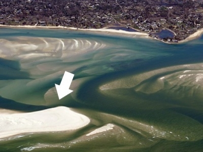
At issue is a narrow passageway between North Beach Island and a shoal to the west, which has become the most reliable channel to the Atlantic from both Chatham Harbor and Pleasant Bay. The area is just outside a previously permitted dredging zone, and thus requires extensive regulatory approval.
Opposing the effort is a group of property owners on Minister’s Point, who have threatened to sue the town over previous dredging, which, they argue, caused more rapid erosion of their property.
In a July 18 letter to the town, their attorney, Paul Revere, III, of Centerville, said he will do what’s necessary to ensure dredging does not take place in the harbor without “the appropriate approvals.
“If you do not agree to meet with me to discuss the required permits by contacting me on or before 5 p.m. on Thursday, July 20, 2018, I will initiate immediately litigation and/or take other action to prevent the dredging from moving forward,” the attorney wrote. Revere represents Gerald Milden and other unnamed property owners in the area; he could not be reached in time to comment for this article.
Chatham Town Counsel Patrick Costello said Tuesday morning that he was unaware of any litigation filed against the town.
In its July 25 meeting, the conservation commission heard from Coastal Resources Director Ted Keon that the southern inlet opposite Lighthouse Beach is essentially shutting down.
“It’s shoaling in. There isn’t sufficient flushing going on to get rid of the sand that’s still coming down naturally,” he said. Instead, the tidal flow is traveling through the north inlet opposite Minister’s Point, creating a deep passage.
“The problem is trying to get to the inlet,” he said. The narrow cut by North Beach Island is wide enough for a single boat to pass, and requires widening to allow safer passage by fishing boats, Coast Guard rescue boats and other larger vessels.
The area is like a three-way intersection, with traffic from the Atlantic, the harbor and Pleasant Bay converging, Holm said. With swift currents and limited visibility, passage is dangerous under normal conditions, and much more so in darkness or fog, he said. The area is a bottleneck that could keep emergency responders from getting out of the harbor, Holm added.
“In that area, if one of the big boats goes aground, there is no response getting out. They can’t get around. They’re stuck there until it’s removed,” he said. That means a response from the Coast Guard boats at Stage Harbor, 45 minutes away “under ideal conditions.”
“To say that it’s a severe situation is an understatement,” Holm added.
The conservation commission received letters supporting the dredge permit from the Coast Guard, the Cape Cod National Seashore, the waterways advisory committee and the Cape Cod Commercial Fishermen’s Alliance.
“As you can see, a lot of people require this action to be taken,” Conservation Commission Chairman Michael Tompsett said. The commission visited the site by harbormaster boat on Monday.
Peter Taylor, a commercial fisherman for 42 years, said he’d rather they made the trip “in the dark in the fog” to fully understand the danger. “You have to go within 20 feet of that beach in the dark in the fog,” he said. “I know the rich people from Minister’s Point are [complaining] about this, but we’re not asking for all those shoals to be knocked down.” The dredging proposed under this permit is a small area.
“We know it is not a long-term solution,” Keon said. Once this dredging is complete, the town may pursue plans to dredge an area closer to Minister’s Point, where the shoaling is less dynamic than it is in the current choke-point, which is closer to the Atlantic.
“I almost had a collision there two weeks ago,” longtime commercial fisherman John Our told the commission. His vessel and another boat missed by inches, he said. “It’s the worst part of my day right now, getting in and out [through] that corner.”
Speaking at the July 25 meeting, attorney Revere chided the town for seeking an emergency certification for the dredging project, calling it “an attempt to get around your normal processes.”
“My clients are not against the fishermen,” he said. “What they are against is willy-nilly quick dredging projects that change flows within the area that impact their property.” Revere said the town was aware of the problem months ago, and it’s not a genuine emergency if “someone takes months to file a permit.”
Tompsett said the changes in the town’s coastline are clearly dynamic.
“This is not a static situation where Ted Keon has been sitting on his hands,” he said. The other permits required for the dredging project have been submitted and are under review.
The residents claim that erosion of their property accelerated as a result of tidal changes caused by the town’s dredging of parts of Aunt Lydia’s Cove in April 2017. Part of the seawall protecting Milden’s property slumped into the ocean following storms last winter.
On Monday, town officials issued a three-page statement acknowledging that coastal erosion is a dynamic system that can have implications for shoreline development, like last winter’s flooding in the Little Beach neighborhood caused by changes in the barrier beach. The town is seeking a grant to develop a comprehensive shoreline study that will recommend shoreline management techniques, to replace its current “piecemeal approach to shore protection,” the statement reads.
“The Town understands the concerns and frustrations of those who own property and reside in vulnerable coastal areas,” town officials wrote. “It will continue to use all resources at its disposal to closely monitor beach and inlet morphology, which ultimately determines shoal and channel patterns within Chatham Harbor, and will work with concerned entities to devise plans and measures to stabilize or improve vulnerable shoreline property.”
Source: The Cape Cod Chronicle


