Posted on April 10, 2018
By Stephen Lee, Capital Journal
Representatives of the U.S. Army Corps of Engineers will hold five public forums along the Missouri River Basin this month, including in Pierre on April 18, to give updates on the “current hydrological conditions and the planned operation of the mainstem reservoir system during the coming months,” according to a news release on Thursday from Army Corps spokeswoman Eileen Williamson.
It’s an annual practice now about this time of year for the Army Corps to explain things at public meetings, along with the regular reports online.
“The updated forecast increased slightly from last month due to the continued accumulation of mountain and plains snowpack in the upper Basin,” John Remus, chief of the Army Corps’ Missouri River Basin Water Management Division in Omaha, said in the news release.
“Based on the current plains and mountain snowpack and precipitation outlooks, runoff into the Fort Peck (in eastern Montana) and Garrison (north of Bismarck) reservoirs is expected to be above average from March through August.”
As of the April 2 forecast for this season, runoff in the Basin above Sioux City is expected to total 30.2 million acre-feet (MAF), which is 119 percent of the average runoff from 1898-2017.
For comparison’s sake, Remus said the 2017 runoff was 29.6 MAF, which was 117 percent of average.
The Army Corps cooperates with the National Weather Service and other agencies, local, state and federal, to monitor the river basin. It keeps track of the snowpack, for example, as well as predicting how much will melt and amount to runoff, versus soaking into the ground.
On April 1, the mountain snowpack in “the reach” above Fort Peck and in the reach from Fort Peck to Garrison Dam was 127 percent of average. Normally the mountain snowpack peaks in mid-April, Remus said.
The plains snowpack varies a lot across the Basin. It’s heaviest in central and eastern Montana and has a liquid content, ro “snow water equivalent,” SWE, of 2 inches and up to 8 inches in localized areas, according to Remus.
“The remaining areas of the Upper Basin have much less plains snowpack, ranging from trace amounts to 3 inches of SWE,” he said.
The Army Corps distinguishes between the mountain snowpack runoff and the plains snowpack runoff largely by the time of the season when the runoff hits the river, a Corps official said. The mountain snowpack tends to runoff after the plains snowpack.
Since the big flood of 2011, the Army Corps developed a better system for tracking and forecasting snowpack runoff and rain and the runoff from rain, an Army Corps official said.
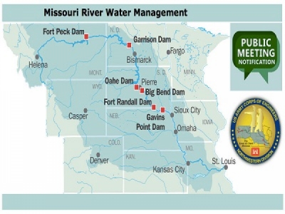
Remus said the mainstem reservoir system of the six big dams, including three in South Dakota, began the 2018 runoff season ready to handle things: with a full 16.3 MAF of “flood control storage to capture the runoff.”
The system’s storage total was 58.3 MAF on April 1, occupying 2.2 MAF of the 16.2 MAF of flood control zone.
“More than 85 percent of the system’s flood storage remains available to capture runoff from the remaining plains snowpack and spring rainfall as well as the runoff from the mountain snowmelt,” Remus said.
In mid-March, the Gavins Point releases were increased from 20,000 cubic feet per second to 24,000 cfs “in support of the Missouri River navigation season,” which began April 1 near St. Louis, he said.
Because of the higher-than-average runoff forecast, the service level of the lower Missouri was increased by 10,000 cfs above “full service to provide beneficial use of the excess runoff while reducing flood risk,” Remus said.
The Army Corps will continue to manage the river by responding to conditions, increasing or not the flows through the big dams.
During March, releases from Oahe Dam averaged 21,000 cfs and the releases are expected to be stepped up to average 24,600 cfs this month.
“Planned releases will primarily be through the powerhouse,” Corps officials said in the news release. “However, outlet tunnels may be used this spring during powerhouse maintenance.”
The Oahe reservoir ended March at an elevation (above sea level) of 1,609.1 feet, after rising 1.3 foot for the month. It’s expected to rise 1.7 foot this month. But it all depends on the pace of snowmelt and how much precipitation falls. At this point, the water behind the dam is at the lower reaches of the over uses including flood control zone, which is right where Army Corps officials want it to be, they say.
he six mainstem dams, through their power plants, generated 697 million kWh of electricity in March, well above the typical March output of 641 million kWh, according to the news release.
This year, the six power plants are expected to generate 11.5 billion kWh of electricity, 23.7 percent above the long-term average of 9.3 billion kWh
The Army Corp’s information is available online at www.nwd.usace.army.mil/rcc/reports.
Anyone interested in getting information in person from the Army Corps is invited to its five public meetings moving up the river April 17-19.
The Army Corps public meetings will begin at 10 a.m., April 17, in Smithville, Missouri, with the second one at 4 p.m., April 17 in Omaha.
The several Corps officials will be in Pierre in the Ramkota at 10 a.m., Wednesday, April 18, near the river at 920 W. Sioux Ave.
The crew will move upstream to Bismarck for a meeting at Bismarck State College at 6 p.m., April 18.
The last meeting will be at 10 a.m., April 19, in Fort Peck, Montana.
Source: Capital Journal


