
Posted on November 6, 2018
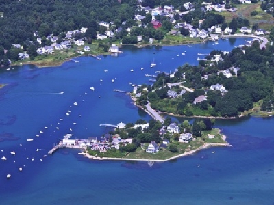
Maintenance dredging of the Cape Porpoise Harbor federal navigation project in Kennebunkport will be performed during 2019 and 2020.
According to the U.S. Army Corps of Engineers, New England District, a private contractor will employ a mechanical dredge and scows to remove material and then take it to either the Cape Arundel Disposal Site or the Portland Disposal Site.
The request for dredging was made by the town of Kennebunkport as deteriorating conditions have made navigation of a dredged channel difficult leading to the sea below the highway bridge at Kennebunkport.
“Natural shoaling processes have reduced available depths to as little as 1 foot in the 15-foot MLLW channel and anchorage, and 2 feet in the 6-foot MLLW channel, making navigation hazardous or impossible at lower stages of the tide,” said Coral Siligato of the U.S. Army Corps of Engineers Programs and Project Management Division in Concord, Massachusetts.
Siligato, who will serve as project manager for the dredging work, said that the project will dredge about 25,000 cubic yards of primarily fine- and medium-grain sand, and silt from about 12 acres of the authorized project area.
Advertisement
“It will maintain the FNP to required authorized dimensions of the 6-foot MLLW channel and will maintain safe navigation to 10 feet MLLW in the 15-foot MLLW channel and anchorage,” Siligato said.
Dredging is expected to take between one and three months to complete and will be scheduled between Nov. 1, 2019, and March 15, 2020. If dredging is not complete in one season, the project will occur the following season within the allowable dredge window.
The window will limit adverse impacts to federally-listed endangered and threatened species as well as avoid the eelgrass growing season, and the spawning of winter flounder and shellfish.
Siligato said that the contractor will be authorized to dredge 24 hours per day, seven days per week.
In recent years, boaters have been advised to exercise extra caution when entering the harbor at ebb tide and in southerly weather with heavy seas running as a result of sediment buildup.
Advertisement
In 2013, the harbor entrance dropped to about 4 feet at low water with the approach to the port marked by two buoys and two spindle day beacons which mark the principal dangers. Currently, the best approach to the harbor is east of the marker buoys.
The U.S. Army Corps of Engineers last dredged the harbor in 1976 when a mechanical dredge removed more than 123,000 cubic yards of sediment from the 15-foot channel, 15-foot anchorage, and 6-foot channel, and then deposited the material at the Cape Arundel Disposal Site.
In recent years, ports along the southern Maine coastline have experienced long delays getting approval for federal navigation dredging projects, which has prompted the Southern Maine Planning and Development Commission to conduct a feasibility study of purchasing and operating hydraulic dredging equipment to perform the work on a more timely basis.
Supported by a $29,000 grant from the Maine Coastal program and the National Oceanic and Atmospheric Administration, SMPDC hired the Woods Hole Group of Falmouth, Massachusetts to examine if such an idea was feasible for southern Maine.
Paul Schumacher, executive director of the Southern Maine Planning and Development Commission, said that 10 southern Maine communities participated in the study, which looked at historical dredge amounts, future dredging needs, the capital and operating costs of purchasing and maintaining a dredge for the region and a financial feasibility analysis.
Advertisement
Some of the 10 participating communities pooled resources and contributed another $5,000 toward the feasibility study, including Saco, Kennebunkport, Kennebunk, Wells, York and Scarborough. Also participating in the study were Ogunquit, Biddeford, Kittery and Elliot.
Schumacher said that the concept has merit, but the limited scope of the feasibility study highlighted additional research needs, but more data is needed regarding the amount of sand materials that might be dredged and reused within southern Maine navigable rivers and harbors.
“I think we need to do more analysis to see if it’s economically feasible,” Schumacher said. “The result of this study is that it’s worth a further look, but we need more data.”
Both SMPDC and the participating communities have outlined some next steps to consider that includes gathering more data about sediment types along the coast, exploring options for use of a dredge with additional Maine or New Hampshire regions, possibly contracting for services over a five to 10-year interim period, and studying funding options for both purchase and lease of dredging equipment.
“One of the things we’re looking at are interim steps, such a contractual lease,” Schumacher said.
Source: JT


