Posted on November 20, 2017
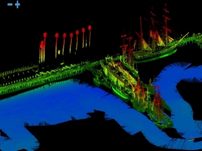
Teledyne Oceanscience announces the release of a new LiDAR sensor option for their Z-Boat 1800RP unmanned surface vehicle (USV) product line. LiDAR is a surveying method that measures distance to a target by illuminating that target with a pulsed laser light, and measuring the reflected pulses with a sensor. Differences in laser return times and intensity are used to make digital 3-dimensional representations of the target. Commonly used to make high resolution maps, the addition of LiDAR coupled with a multibeam echosounder on the Z-Boat 1800RP enables mapping and surveillance capabilities both above and below the waterline.
The Z-Boat 1800RP’s new LiDAR was demonstrated at the Maritime Alliance Blue Tech Week in San Diego, California this past week. The live demonstrations, held adjacent to the San Diego Maritime Museum on the waterfront last Thursday, provided a great opportunity to demonstrate the high resolution capabilities of the Z-Boat 1800RP with mounted LiDAR and Odom Hydrographic multibeam echosounder. Teledyne Oceanscience Z-Boats are used extensively by researchers and hydrographers around the globe to scan and map the bottoms of rivers, streams, lakes, and flood areas. The new ruggedized Z-Boat design also enables its use in shallow coastal areas.
“The new Z-Boat mounted LiDAR opens up an entirely new mapping capability for the Z-Boat” stated Ashley Cantieny, Teledyne Oceanscience Mechanical Engineer. “We’re very excited to introduce this new sensor to our customers.”
Applications for the Z-Boat mounted LiDAR sensor include ports and harbors, environmentally sensitive areas, construction and inspection zones, dams and reservoirs, harbors, rivers, and more.
Source: Teledyne Marine


