Posted on February 11, 2020
SUNSET BEACH — After a yearslong effort to deepen narrow waterways, Sunset Beach has appealed the state’s dredging permit, seeking to dredge material at a deeper depth than federal and state agencies recommend.
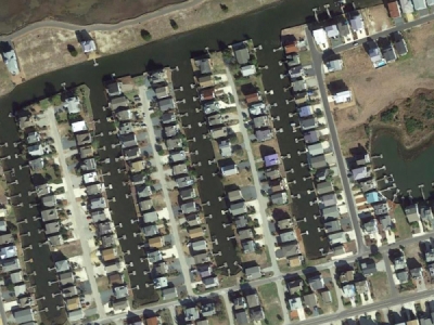
In October 2019, the Division of Coastal Management (DCM) approved the town’s Coastal Area Management Act Major Permit to dredge its four ‘finger canals,’ feeder channel, bay area, and south Jinks Creek. This activity would disturb approximately 18 acres of shallow bottom habitat — regardless of how deep the town is permitted to dredge.
Related: The EPA just rolled back protections for wetlands. What does it mean for Cape Fear region?
Sunset Beach first applied to dredge these areas to 5 to 6 feet below the mean low water (MLW) line; each section is currently less than 3 feet below the MLW line, with south Jinks Creek having the most shallow bottom. The CAMA permit approved the town’s request, but limited dredging to just 2 feet below the MLW line, in accordance with the state environmental regulation that prohibits excavation below the depth of connecting waters.
So, late December, Sunset Beach filed an appeal of the state’s decision, seeking a variance from the state regulation to dredge the areas to five-to-six feet below MLW as originally proposed. Despite concerns raised by a host of local, state, and federal agencies, a Jan. 30 staff report compiled by DEQ’s general counsel agrees with Sunset Beach’s variance request.
The state’s environmental governing body, the Coastal Resources Commission, could make a determination on Sunset Beach’s request next week.
Under the Division of Water Resources’ Shallow Draft Navigation Channel Dredging Channel and Aquatic Weed Fund, the DEQ has already agreed to pitch in $3.7 million for the project, with Sunset Beach required to match one-third of the total cost with $1.8 million.
Justification, responses
Sunset Beach was developed in the early 1970s by Mannon Gore. Early dredge work was conducted prior to the 1974 Coastal Management Area Management Act, which meant Tubbs Inlet was relocated without a permit.
This work created four, man-made finger canals (long, narrow canals). For 50 years, no dredging activities have been permitted or conducted in Jinks Creek or the bay area. The feeder system was dredged under 1985 and 2002 CAMA permits.
Jinks Creek is not technically designated as a Primary Nursing Area, a protected classification that prohibits dredging activities, but the National Marine Fisheries Service and Division of Coastal Management staff believe the creek functions as one.
Dredging activities would negatively impact oysters, clams, and mussels that live in and along Jinks Creek. Of the 89,100 total cubic yards proposed to be dredged, approximately 40,500 cubic yards removed from Jinks Creek would be reused. Jinks Creek material contains a higher-quality grain and would be applied along 8.5 acres of oceanfront between 5th and 12th Streets.
This activity would cause “temporary mortality” of intertidal species, according to a DCM analysis last year, impacting crabs, worms, and possibly interfere with sea turtle nesting season.
Dredging activities are needed, the town asserts, to maintain navigable access to the Intracoastal Waterway. Originally, the town sought to dredge the entirety of Jinks Creek, but later reduced its plans to address a portion of south Jinks Creek following the recommendation of several government stakeholders.
The project has sharply divided town residents and stakeholders.
Waterfront property owners along the finger canals and proposed dredging areas are mostly in favor of the project. In recent comments to the variance request, many property owners say the maintenance activity will restore recreational boating access, which has grown to be nearly impassable outside of high tide due to shoaling. It would also increase property values, many comments report, which have lulled in recent years due in part to restricted navigable access.
But those opposed to the project question its legitimacy and assert it only benefits a small fraction of waterfront property owners. At the approved depths, flat-bottom boats could still have increased water access, but those opposed to the project say there is no need to provide deeper clearance for v-hull vessels.
The Town itself is not unified in its efforts: Councilman Rich Cerrato condemned the project, describing it as “greed” in his comments last month to DCM, while Councilwoman Jan Harris also remains opposed to the variance request. Councilman John Corbett, who owns property on Canal Drive, signed a no conflict of interest submitted to the DEQ in May.
Barry Lentz, Professor Emeritus at the UNC-Chapel Hill Department of Biochemistry and Biophysics, wrote in his comments to DCM last month that the town’s request makes false and “ridiculous” claims of hardship in its variance application.
Both the North Carolina Coastal Federation and Southern Environmental Law Center have asked the state to deny the town’s variance request.

Send tips and comments to Johanna Ferebee Still at johanna@localvoicemedia.com
Source: portcitydaily.com


