Posted on March 12, 2019
[Steve Heaslip/The Cape Cod Times]
CHATHAM — Last summer’s fleet departure for the fishing grounds looked like a parade, fisherman John Our said, with 30 vessels leaving and returning at the same time at Aunt Lydia’s Cove. They were trying to make the most of a diminished tidal window, as shifting channels and sandbars made it hard to find water deep enough at either of the harbor’s two inlets for the commercial fishing fleet to get from the municipal fish pier to the Atlantic Ocean fishing grounds.
“It’s not working, and it’s really affecting everybody’s business,” Our said.
Things aren’t going to get better anytime soon, for fishermen or waterfront property owners, experts told a full house Thursday night at an unveiling of preliminary findings from an ongoing study of coastal resiliency and adaptive management for Chatham’s east-facing shoreline. The nearly $250,000 study, with a $188,122 grant from the state’s Coastal Zone Management agency, is scheduled to be completed this June. It uses computer modeling combined with site work to assess current conditions and look into the future of Chatham Harbor and Pleasant Bay and what steps the town can take to mitigate impact.
John Ramsey, the principal coastal geologist at Applied Coastal, the Mashpee-based consultants Chatham hired to do the study, said analysis showed that Chatham Harbor is operating as two separate systems.
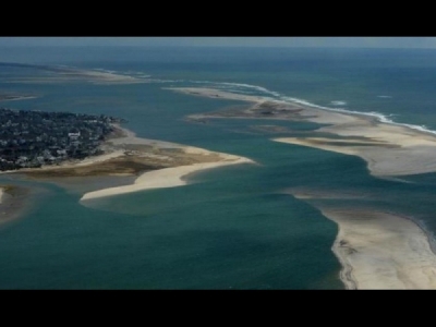
One serves as a tidal pipeline between Pleasant Bay and the Atlantic through the North Cut, a ½-mile wide inlet in the barrier beach that protects the mainland. It was created by a series of nor’easters in April 2007.
The southern system, which includes the municipal fish pier and the main mooring field for the commercial fleet, is now essentially cut off from Pleasant Bay. That results in a diminished tidal flow through the 1987 Chatham Break, which once served as the only entrance to the harbor and Pleasant Bay, which is not strong enough to maintain a navigable channel to the sea.
While the commercial fleet, one of the largest and most active on the East Coast, was able to use the North Cut last year, the most recent report shows a large, wide sandy plateau that is 4 to 5 feet deep at high tide, too shallow for most commercial vessels, effectively cutting off the fleet off from its only deep-water highway to the sea.
It’s part of a 150-year cycle, identified by geologists such as Graham Giese of the Center for Coastal Studies, in which the barrier beach off Chatham stretches south toward Monomoy until it gets so thin at one or more spots that storm waves break through. Sand traveling along the shore eventually rebuilds the barrier beach, but until it does, waterfront property owners may experience increased erosion and exposure to the energy of ocean waves, Ramsey said.
Think of an inlet as a stabilizing influence, trying to hold the channel in one spot by the force of the water flowing in and out of Pleasant Bay. But that tidal flow also interrupts the conveyor belt of wave-driven sand from the north, starving North Beach Island of the sand it needs to rebuild the erosion by waves and currents. Ramsey said the island will likely face rapid erosion in the near future and could vanish altogether as it did back in the 1870s. That would leave homeowners with an ocean view they don’t want.
“Eventually they will get a lot of sand, but in the interim they could see increased erosion and impact from storm waves,” Ramsey said.
The point of the study, said Chatham Coastal Resources Director Ted Keon, is to find what defenses and strategies the town should pursue if they are facing that possibility in the near future.
“The next phase (of the study), yet to be completed, is how the physical changes will occur, the breakup of the inlets, the movement of the shoals, and what are the appropriate measures to plan for and get started on, based on the predicted changes,” Keon said.
Erosion is something homeowner Gerry Milden is already experiencing. His Minister’s Point home looks out on the North Cut. He contends it was town dredging of Aunt Lydia’s Cove to the south that caused a strong current to flow past his home, scouring out a deep hole that undercut a stone revetment protecting his property, leading to a partial collapse.
Computer modeling in the preliminary study contradicted that theory, revealing a weak northerly current from Aunt Lydia’s Cove. Ramsey said the damage to Milden’s property was likely caused by a shift in the northern channel leading out to Pleasant Bay unrelated to dredging.
Milden does not agree, and he has appealed in Barnstable Superior Court and to the Department of Environmental Protection the Chatham Conservation Commission’s order of conditions that allowed the town’s plan to dredge a channel to the North Cut across the plateau. Town officials are worried that the DEP decision, the court case and appeals, combined with seasonal dredge closures to protect spawning fish and shellfish, will delay the dredging into or beyond the new fishing year, which begins May 1.
“I think the town has been taking it seriously,” Our said. Fishermen have largely stayed out of the approval process for the stone revetments that protect property, Our said, but they may have to reconsider that because he believes the walls can alter channels.
“Everyone needs to work hand-in-hand here,” he said.
— Follow Doug Fraser on Twitter: @dougfraserCCT.
Source: southcoasttoday.com


