Posted on April 25, 2017
By Ellen Ebsary, The Border Mail
A combination of two levees costing $1.6 million has been recommended as a solution to reduce the impact of flooding in Holbrook.
The Holbrook Floodplain Risk Management Study was adopted by Greater Hume Council on Wednesday.
It put forward a range of measures including designating a flood-way, developing a database of all drainage infrastructure and setting up a telephone dial-out and SMS system for emergency flood information.
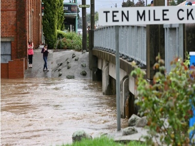
Two levees were nominated as protection – one running parallel to Macinnes Street and Ten Mile Creek, extending to the Holbrook Bypass southern off-ramp, and another along Hay Street, 1.85 metres in height.
WMAwater, the organisation compiling the report, recommended detailed costing and design of the levees be undertaken.
It was also noted “residents have raised concerns with the amount of debris in Ten Mile Creek and the possibility of dredging the creek” and vegetation management should be investigated.
The Murray Local Land Service is responsible for Ten Mile Creek at Holbrook but clearing or dredging on a broad scale would require NSW Fisheries approval.
In responding to questions about a vegetation plan with the arms of government involved, Engineering director Greg Blackie said it would be a 12-month process at least.
“It’s not going to happen overnight,” he said.
“What they’re hoping for is not just a clearing regime; they want a management process.
“Yes, the vegetation is a bit high in there at the moment and we are planning to do some work.
“The vegetation has some affect, but the issue is looking at something much bigger.”
For Culcairn, recommendations included:
– Management of vegetation in Billabong Creek to prevent blockage impacts on flood behaviour
– Lowering the Stock Route near the Balfour Street Intersection
For Jindera:
– Upgrade the drain between Urana Street and Molkentin Road
– Prepare a local flood plan
And for Henty:
– A levee along West Showground Road and Pleasant Hills Road, along Grubben Road, and on the eastern side of the OlympicHighway
– Management of vegetation in Buckargingah Creek.
Source: The Border Mail


