Posted on July 26, 2020
COOS COUNTY, Ore. — Toward the end of 2019, a boat capsized in the Charleston Marina in Coos Bay.
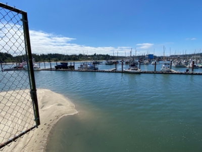
The accident happened because of a sandbar, and now officials are working to get this dangerous location dredged.
During a town hall in January held by senator Jeff Merkley, a citizen brought to his attention there was a hazardous portion of the channel in Charleston. Since then, his office has been working with the Port of Coos Bay and the Army Corps of Engineers to resolve the issue.
The only problem is that the sandbar is not in the federal navigate channel for the corps of engineers to dredge.
“We almost go right up to it and I’d say our federal channel stops 10 or 20 feet before that sandbar,” said Greg Speer, the Oregon Coast Project Manager.
In may the Port of Coos Bay and Senator Merkley have written and sent a letter of interest to the Army Corps of Engineers asking for this area to be added to the federal authority.
“We’ve seen a pretty significant increase in the shoaling in the last 4-5 years,” said Margaret Barber, the Director of External Affairs. “I’m not sure if it was something to do with the segmentation or current.”
According to the Army Corps of Engineers, they will have to do a feasibility study to see if they can get this added to their authority. Something like this could take two years.
“We would have to look at the surrounding structure you know around there is a brink water and we would have to determine the depth that we could dredge there so that we didn’t undermine the jetty or any of the pier or damage anything else in the process,” Speer said.
Speer says once the study is done, congress would have to approve the added area to the federal navigation channel.
In the meantime, mariners should be aware of the sandbar as there is no markers indicating the location.
“The difficulty with that is that the shoaled area moves around so I think the danger of putting a marker out is it might give people a false sense of security,” Barber said.
Ultimately, things are in motion in hopes to resolve the hazardous portion of this navigation channel.
Source: kcby


