
Posted on November 17, 2016
By Catherine Kozak, The Outer Banks Voice
While much of Hatteras village suffered losses from Hurricane Matthew, the storm did remarkably little to change conditions in Hatteras Inlet for the charter fleet.
“The inlet has moved a little bit, and the channel has moved a little bit,” said Steve “Creature” Coulter, a Hatteras charter boat captain. “I wouldn’t say anything has changed. But it hasn’t gotten any better – and it hasn’t gotten any worse.”
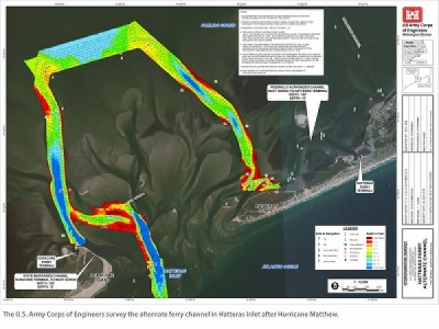
Post-storm surveys taken of the inlet shown at Monday’s meeting of the Dare County Waterways Commission showed a familiar picture of the channel, with the bend in Barney Slough pinched by shoaling.
“When the wind’s bad, it’s especially tough making those turns,” Coulter, a commission member, told the panel.
But the storm did clog the ferry channel near the Ocracoke South Dock, requiring the new state dredge Manteo to remove more than 30,000 cubic yards of material to allow safe transit for the larger vessels. The six-day project was completed over the Veteran’s Day weekend.
“When we’re talking about Hatteras, “said Steve Shriver, team leader of the U.S. Army Corps of Engineers’ survey section, “we’re kind of talking about two customers – the ferries and the commercial charter fleet.”
The members of the board in attendance were Dan Oden, Fletcher Willey, Ernie Foster, Ronald Lowe, Danny Couch, Chairman Dave May and Coulter.
For more than a year, Hatteras charter captains have been inching their way to and from the ocean through whatever safe passage they can find. But the Coast Guard has had difficulty moving buoy markers to appropriate water because of shoaling and bad weather. As a consequence, the captains have ignored the Coast Guard buoys and used their own poly balls to mark good water.
So far, the local fleet has managed, commission members agreed, but it hasn’t been good for business. Although the Coast Guard issues warnings about the inaccurate channel markers, and to not come into the waterway without local guidance, there are still occasional boats that run aground.
Manuel Gonzales, officer in command at the Coast Guard’s Aids to Navigation Team in Wanchese, said that it has been impossible to get their buoy tender to the buoys from both the ocean side and the interior channel.
“It’s kind of like a buoy graveyard,” he said. “You need some time for some good weather so (the tenders) don’t get stuck out there.”
Gonzales said he would look into the possibility of removing the sea buoy and buoys 2 and 3, which are outside the channel. Then the good water could be remarked.
“It’s a straight shot,” Coulter said. “We can poly ball it and people can have a better chance of getting where they’re going than they have now.”
Between the constraints created by weather and shoaling, the most immediate hope for a solution to the navigation issues is a planned dredging project in the Connecting Channel between the South Dock on Ocracoke and the Inlet Gorge.
Dare County Board of Commissioners Vice-Chairman Wally Overman said that applications for the project — dredging of the ocean bar and the interior channel — were submitted to the appropriate agencies in late October, and the permitting process is on schedule to meet the targeted start in March. Concurrently, the county is seeking a Memorandum of Agreement with the state and the Corps to fund the dredging.
“I don’t see, barring some unforeseen hiccup, that this thing will go off track,” Overman said.
Once the permits and the MOA are acquired, the Corps anticipates being able to do the county project, along with its regular maintenance dredging in Rollinson Channel, said Roger Bullock, Corps’ chief of navigation. The length of time involved for dredging will depend on the amount of shoaling, he said.
At the same time, the Corps is also looking further out into the future, he said, in the hopes that the former historical ferry channel, the so-called “short route” between the Hatteras docks and the Inlet Gorge – with the help of Mother Nature – will start to open up.
“The short route right now – we cannot navigate it,” Bullock said. “And if we can’t navigate it, we can’t dredge it.”
A geotechnical contractor hired by the agency, he said, is currently taking soil samples in anticipation of the Corps conducting an environmental assessment for advanced maintenance in the federal channel. If the project becomes do-able, it would place 50-foot “wideners” on either side of the authorized 100-foot wide channel.
“We just want to have a full picture out there,” he said.
Bullock explained in a later telephone interview that if the eroded tip of Hatteras Island does the normal coastal pattern of rebuilding, the Corps wants to be ready to act. But so far, regular surveys in the last year have shown barely any change.
“We have to be very patient,” he said. “Mother Nature is going to dictate where that channel is going to be, and there’s not a lot we can do about it.”
The next meeting of the Waterways Commission will be held on Dec. 12 at 7 p.m. at the Fessenden Center in Buxton.
Source: Island Free Press


