
Posted on December 18, 2018
After 18 months of development, the Lake Mattamuskeet Watershed Restoration Plan has been submitted for final approval by the state.
Once the state Division of Water Quality 319 Grant Program approves this plan, which was created to improve the habitats and water quality of the lake, the centerpiece of the Mattamuskeet National Wildlife Refuge in Hyde County, stakeholders will be able to move forward with securing 319 grant funding that can then be used to implement the steps identified in the plan.
Originally 110,00 acres and 6 to 9 feet deep, the now 40,000-acre, 2 to 3 feet deep lake is the largest naturally formed in the state but, due to 200 years of hydrologic modification, is no longer considered a natural lake. In 2016, the lake was listed as an impaired waterbody on the state 303(d) list because of high levels of chlorophyll-a and alkalinity. Additionally, the lake in the last few years has lost all submerged aquatic vegetation, or SAV, a food source for waterfowl and habitat for fish.
Flooding is another issue in the watershed due to a passive drainage system that has been compromised by rising sea level. There are four major outlet canals that were excavated before 1950 to move water from the lake to the Pamlico Sound, according to the restoration plan. “Each of the canals have a set of tide gates that operates on differences in head pressure to ensure Lake Mattamuskeet remains a freshwater system by preventing saltwater intrusion from the Pamlico Sound. Rising sea levels and siltation of the main canals connecting the lake to the Pamlico Sound are thought to be contributing factors in the decline of drainage function, and those conditions are anticipated to exacerbate flooding in the future.”
During the 18-month drafting process, Hyde County, U.S. Fish and Wildlife Service, North Carolina Wildlife Resources Commission and other stakeholders identified three goals for the plan, which are to protect the way of life in Hyde County, actively manage the lake water level and restore water quality and clarity. The stakeholders identified six objectives and several actions to reach these three goals.
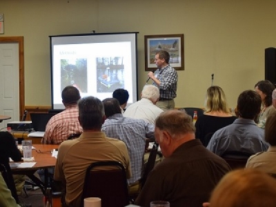
The North Carolina Coastal Federation, which prepared the plan, led a public symposium Dec. 3 to present the final draft.
The planning development process began in May 2017, and since then there have been five public meetings and 14 stakeholder meetings. A draft of the plan became available Oct. 16 and the final, 200-page document available on the federation’s website.
Bill Rich, Hyde County Economic Development consultant, explained to the about 100 gathered for the plan’s unveiling in Martelle’s Feed House Restaurant that Lake Mattamaskeet is “important to us for many reasons,” including serving as the centerpiece of the county, playing a vital role in the county’s recreation, namely birding and hunting, tourism, “and is also the blood of Mattamuskeet Lodge. Without a healthy lake we do not have a healthy lodge.”
Rich said that a diverse group teamed up to write the plan. “We all came together to see if we could figure out a path forward to improve the lake and conditions around the lake … we have a vision for where we are going and we’ve identified some key steps to move forward.”
Erin Fleckenstein, coastal scientist and northeast regional office manager for the federation, explained that during the planning and development process, there were many concerns about the lake, watershed, agricultural and residential property flooding, the loss of SAV in the lake, “which is an important indicator of the health of the lake,” and water quality parameters tested in the lake.
“The levels of pH and chlorophyll-a in the lake are higher than the state standard for them. We also had concerns about elevated nutrient levels of nitrogen and phosphorus,” Fleckenstein said. “The elevated pH and chlorophyll-a is what caused the lake to be listed on what is called the 303(d) list for impaired waterways, that means the lake is not meeting its current use standards and steps need to be taken to make sure it can be returned back to its health.”
Michael Flynn, coastal advocate in the federation’s northeast office, said that there’s no active management at the lake, which has contributed to the flooding of private property, extended septic tank use interruptions and inadequate croplands drainage. There is turbid and hypereutrophic, or extremely nutrient-rich water, SAV has been documented as absent since 2017, plus there’s an abundance of common carp, an invasive species.
Flynn told the crowd that the stakeholders came to the conclusion that active water management within the watershed is a top priority.
“We want to see active water management that addresses the lake level. Helping to manage water throughout the watershed would result in less-frequent flooding of residential property and fewer septic system failures and adequate drainage of croplands will be available,” he said. “We’d like to see it move from turbid and hypereutrophic to clear and mesotrophic, have the right amount of nutrients to support the habitat that’s desired, see an increase of SAV along the lakebed and emerging vegetation along the lakeshore, reduction in common carp population … and ultimately, removal of the lake from the NC 303(d) list of impaired waters.”
One priority action listed in the plan is to create a formal body that provides managing authority for active water management within the watershed in close coordination with the refuge, Flynn said. Another priority action is to perform a hydrologic study of the watershed to get a better idea of how the water should be managed.
To transition from the study to designing plans for active water management would help identify what infrastructure improvements would be needed, he added.
Wendy Stanton, terrestrial ecologist with the U.S. Fish and Wildlife Service, said that one of the purposes of the refuge is to protect and conserve migratory birds, especially waterfowl, and other wildlife resources, through the protection of wetlands in the lake.
The splendor of the lake was the SAV, she said, “There were massive mats of SAV in the lake and that provided important habitat for waterfowl and fish and many other species.” Now, the current condition of the lake is turbid, unclear water with the SAV pretty much completely disappeared, dominated by cyanobacteria and other phytoplankton.
“In summary, we have excessive nutrients in the lake, we have lost our SAV, but on the bright side, we have this whole group here under the leadership of the federation and great partnerships to try to restore the SAV and improve water quality in the lake and help our adjacent communities,” Stanton said.
April Lamb, graduate student at North Carolina State University, explained that she was evaluating the feasibility of removing the invasive common carp introduced mid-19th century, as well as the potential for a vegetation restoration project to get SAV back in the lake.
As part of her project, about 140 acres of the lake has been sectioned off that around 3,200 carp will be relocated from, and monitor water quality changes. Alongside the carp removal process and monitoring to see how carp are impacting the system, wild celery and white water lily will be planted and caged to prevent carp and turtles from grazing on the new plants.
Randall Etheridge in the agricultural and ecological engineering department at East Carolina University said that he is still working on data collected about the waterfowl impoundments’ potential impact on lake water quality, but “to summarize what we know so far, waterfowl impoundments, no matter what type, at least from what we’ve seen, are contributing nutrients and sediments to the lake.”
Etheridge also studied the canals in the lake and discovered that the insides of the canal pipes are filled with sediment, and that along with sea level rise, are causing the reduction of flow. Another factor is the tide driven by water levels in Pamlico Sound.
Pete Campbell, refuge manager, reminded the audience that Lake Mattamuskeet is the premier waterfowl refuge on the Atlantic Flyway, but is also important to Hyde County and the waterfowl community, which depends on birds being at the lake.
“The visitation has really gone through the roof at the refuge in the last five to 10 years,” he said, adding the waterfowl counts are very high. “Up until a point it could change, we don’t want that to change. Therefore, we are committed with working with our partners not to put this on the shelf but to move forward with it and to exhaust every opportunity to acquire necessary resources to make this thing happen.”
He added that everyone realizes the lake didn’t get in this condition overnight and will not return to its normal condition overnight.
With reports of the effect of sea level rise and climate change in the area from 2050 to 2100, Campbell said he knows the county has been looking at resiliency actions and what looking at what the communities can do to prepare for those conditions. “And we can do the same in the watershed but sooner than later, we can only do so much and we have to understand that. It’s the reality of the situation. Can we buy time? Yes. Can we buy time and clean the lake? Yes, can we protect property? Yes, for how long? if I knew that answer, I’d be a rich guy.”
Wilson Daughtry, an Englehard resident with the Mattamuskeet Drainage Association, told the crowd that a few years ago the association partnered with the federation on a watershed restoration plan for the 42,000 acres the association manages, which was a very similar to the process of the Lake Mattamuskeet plan.
Daughtry told Coastal Review Online after the symposium that he is an adjoining land owner who has has worked with the federation in the past on a watershed restoration plan and was a sounding board for this project. Now, moving forward, the plan will need to be approved to become eligible for funding, “And then the real work starts.”
Campbell said in an interview that in the springtime, the refuge will have to post warning signs about the toxicity of the lake. When the temperature rises, cyanobacteria, or blue-green algae, increases, which causes the toxicity level goes up.
“The refuge has been part of the 18-month process from the get-go, and one of the three primary stakeholders that contributed to the funding to hire the Coastal Federation to facilitate the planning process,” he said.
The water quality of the lake is very bad, Campbell said, and he’s hoping that through this joint effort they can reverse the trend and “get it back to a manageable state where the vegetation can be established, the water quality will improve and those signs will go away, as an example.”
He added that it wasn’t an overnight degradation process, and it’s not going to be an overnight restoration process. “It’s going to take a lot of heavy lifting and a lot of cooperation between the refuge and the service district that will be part of the rest of the watershed,” Campbell said. “It’s going to take a lot of financial resources, we will need a lot of support, not only from the community here, but from folks at the state and even at the national level.”
Flynn said after the meeting that the final plan is a result of participation from stakeholders, and the implementation of this plan will require the same.
“I think the quantity of residents, members of the scientific research community, and staff from regulatory agencies and nonprofit organizations in attendance at the recent public symposium held to unveil the final plan is an excellent indication of the vested interest and commitment to the implementation of the plan,” he said. “It was also very encouraging to see representatives from the offices of Sen. Burr and Sen. Tillis in attendance at the public meetings and symposium.”
Source: Coastal Review Online


