
Posted on July 28, 2016
By Allison Petty, herald-review.com
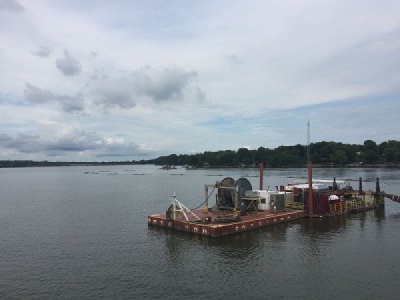
Dredging operations on Lake Decatur have made their way into Basin 2, generally the area of the lake most populated by boaters.
The work started there early last week, said Jerry Stevens, engineering services coordinator for the city’s water management department. Crews previously were dredging in the Big Creek area.
Great Lakes Dredge & Dock, the city’s contractor for the $91 million dredging project, is now about 30 percent complete with the work, which began in fall 2014. The city so far has gained about 15 extra days of water, with a total of 52 additional days expected after the end of the six-year effort.
There are three booster stations that help to propel sediment through a pipeline from the lake to a 523-acre storage site in Oakley. The stations are located near Lost Bridge Road, U.S. 36 and Faries Parkway.
Two smaller dredges are still slated to begin work in Sand Creek later this summer, but have been delayed because some equipment has not become available from another job, Stevens said. Those operations are likely to begin by mid- to late August.
An area on the north side of Grove Road is being cleared to give crews a place to launch and work from, he said.
Boaters should stay at least 150 feet away from the dredge at all times, Stevens said, as well as away from the pipe that floats in back of it.
“They’ve got a lot of light and things to locate and warn the boaters about where the piping is,” Stevens said. “We knew that was going to be a little bit more of an inconvenience, because that’s where most of the boat traffic is.”
Another part of the project has been increasing capacity of the basin in Oakley where the sediment is stored. The earthwork has been hampered by weather at times over the past two years.
Now, Stevens said that work is wrapping up and should be completed by the end of August.
Once the Sand Creek and Basin 2 areas have been dredged, crews plan to move into Basin 3 and then Basin 4.
The location of the dredge and booster stations can be seen on the city’s website, decaturil.gov, by clicking on the “Lake Decatur Dredge Location Map” button on the left side.
Source: Herald & Review


