
Posted on October 24, 2016
HYPACK has partnered with Infinite Jib, Velodyne, and SBG to provide a unique and cutting edge mapping solution that represents the next evolution in the Unmanned Aerial Vehicle (UAV) market.
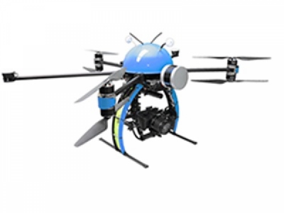
The NEXUS 800 powered by HYPACK is a full end-to-end solution that represents a new paradigm in Unmanned Aerial Vehicle (UAV) data collection by seamlessly harmonizing LiDAR data with photogrammetry. The NEXUS 800 is an out of the box turnkey system that tightly integrates hardware and software to provide an advanced and seamless solution for LiDAR survey planning, data acquisition, post processing and analysis, and product creation.
The NEXUS 800:
• Provides a full GNSS aided inertial navigation system
• Visualizes LiDAR return with a 360 degree field of view
• Acquires LiDAR and Photogrammetric data using our powerful and user-friendly HYPACK-HYSWEEP software
• Displays Real-Time photogrammetry and Point Cloud viewing
• Provides Point Cloud and georeferenced photogrammetry correlation via post processing
• Includes an On-board Windows® PC for rapid data processing and product creation
• Allows volume computations and data analyses
• Includes a comprehensive full flight system, training and support.
Powered by HYPACK-HYSWEEP mapping software, the operator can plan, acquire, and process the LiDAR and Photogrammetry data onboard a high powered Windows PC and high performance UAV allowing for rapid analysis, product creation and export to a variety of CAD and GIS formats.


