
Posted on January 9, 2019
Critics say the Army Corps of Engineers never saw a flood control project it didn’t like. The agency is swinging for the fences again in 2019 with the rollout of what could be the most expensive public works project in the agency’s history.
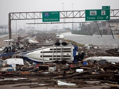
What began as a $10 billion flood wall proposal to protect Galveston Island and the Houston Ship Channel ballooned to between $23 billion and $32 billion. The project, spurred by the devastation of Hurricane Ike in 2008, also got a new name to match its rising price tag.
Once called the “Ike Dike,” the megaproject is now named the Coastal Texas Protection and Restoration plan.
The 70-mile “coastal barrier system,” drafted by the Army Corps and the Texas General Land Office, could be decades away from funding and construction. A feasibility study is receiving its first formal public review, and even proponents acknowledge that the network of flood walls, navigation gates, ring levees and coastal restoration projects could test the limits of government action.
“There are a lot of details that still need to be worked out,” Army Col. Lars Zetterstrom, commanding officer of the Army Corps’ Galveston District, said in a public meeting last month.
Meanwhile, opponents are mobilizing.
Residents of Galveston and the adjacent Bolivar Peninsula fear diminished or lost ocean views and shrinking property values. Taxpayer watchdogs are barking over the plan’s eye-popping cost estimates. Environmentalists warn that it would be nothing short of an ecosystem amputation for the Texas coast.
But virtually everyone agrees that the Texas coast is more vulnerable than ever. Warming oceans, sea-level rise and the prospect of stronger, wetter, more destructive hurricanes put the nation’s fifth-largest population center in the crosshairs of climate change.
Here are four more major flood projects expected to reach important milestones in 2019:
FARGO-MOORHEAD AREA DIVERSION PROJECT
Minnesota regulators last month approved a long-awaited permit to advance a $2.2 billion dam and diversion channel on the Red River of the North. The Red drains hundreds of square miles of farmland along the Minnesota-North Dakota border, but spring floods pose multibillion-dollar risk to two river cities, Fargo and Grand Forks, N.D. (Climatewire, Oct. 27, 2017).
Catastrophic flooding in 1997, 2009 and 2011 solidified federal and local determination to build a high dam, an embankment structure and a 36-mile diversion channel to bypass water around Fargo during spring floods. Scientists say inundations will become more common with climate warming.
The project stalled after a group of upstream landowners, joined by the state of Minnesota, claimed the project would flood private property and violate Minnesota’s floodplain laws. Negotiations between the states’ governors, followed by revisions to address Minnesota’s concerns, put the project back on track last month.
But Minnesota attached 54 conditions to its pending permit, driving the project’s cost to $2.75 billion. North Dakota lawmakers, facing an additional $300 million in shared costs, are grumbling in Bismarck. And a new landowner lawsuit appears to be brewing upriver. Stay tuned.
Northern California has a long and harried relationship with water impoundments, none more serious than the near-failure of the 770-foot Oroville Dam north of Sacramento in February 2017.
That’s when an undetected crack in one of the dam’s concrete spillways erupted as a winter storm filled Oroville Lake to near capacity. Nearly 190,000 people evacuated as officials scrambled to correct the problem. Days later, two seismic tremors in the same area sent a new wave of fear through the Sacramento Valley.
The California Department of Water Resources, which is responsible for the dam, spent hundreds of millions of dollars on repairs, whose cost is now projected to reach $1.1 billion. The state hopes to recoup 75 percent of that from the Federal Emergency Management Agency. But FEMA says it might not pay the full amount after finding that the spillway failure could have been caused by poor maintenance and errors in design and construction.
Meanwhile, the Army Corps is working to expand the capacity of another massive reservoir, Folsom Lake, about 25 miles east of Sacramento in the foothills of the Sierra Nevada. The Army Corps is raising the lake’s primary dam by 3.5 feet.
Army Corps officials maintain that the Folsom project, which includes the recent construction of a second spillway, will improve flood protection for Sacramento, one of the nation’s most at-risk cities due to its location below the confluence of the Sacramento and American rivers.
The dam raising, combined with associated flood-control projects at Folsom Lake and along the Sacramento River, will come at a cost of nearly $3 billion.
HERBERT HOOVER DIKE
The 143-mile levee ringing Florida’s Lake Okeechobee has been a thorn in the Army Corps’ side for decades.
Environmentalists may never forgive the agency for severing the Everglades from its primary water source nearly a century ago. The 60-year-old Herbert Hoover Dike has created or contributed to another set of environmental concerns, from toxic algae blooms to chronic seepage and risk of outright failure.
The Army Corps began reinforcing the dike in the early 2000s and spent more than $870 million on new flood control structures through 2016. But two unprecedented hurricane seasons since then, including some of the most powerful and rain-intensive storms on record, have made Floridians more nervous than ever that a storm tracking across “Lake O” could overtop the dike and send torrents of polluted water across South Florida.
After 2017’s Hurricane Irma, which crossed the Florida Peninsula north of the lake and raised water levels to a 12-year high, the Army Corps secured another $517 million in emergency funding to finish the job by 2022. The total cost: $1.7 billion.
The Army Corps does not use the word “project” lightly. So when it names something a “megaproject,” as it did with the expansion and rehabilitation of a 175-foot-high concrete dam on West Virginia’s New River, taxpayers should take notice.
The project, which calls for raising the 70-year-old dam by 8 feet and building an auxiliary spillway to reduce the risk of water overtopping the dam during heavy rains, has been ongoing since 2000. It received a major cash infusion last year when Congress allocated nearly $575 million to complete phases 4 and 5. The final cost will approach $800 million.
According to the Army Corps, Bluestone Dam provides flood control for an area nearly the size of Connecticut, and 50 percent of the water flowing through the state capital at Charleston flows through the dam. But its original design, which relied on the dam’s own weight to hold back water, was deemed insufficient to meet today’s flood risks. So the Army Corps is anchoring the dam’s foundation to bedrock while simultaneously increasing its holding capacity.
Bluestone dodged a bullet last year when Hurricane Florence made a northward turn before reaching the west side of the Appalachians, where a half-dozen rivers converge to charge Bluestone Lake.
The densely forested southern Appalachians are experiencing more significant disaster events, including river floods and fires that are expected to grow worse as the climate warms.
Source: Scientific American


