
Posted on May 2, 2019
Today the lagoon is full of plant and bird life
San Dieguito Lagoon is the largest of San Diego County’s six lagoons and is part of the 92,000-acre San Dieguito River Park. The park contains the Coast to Crest Trail, which will eventually run from Volcan Mountain near Julian all the way to the coast at Del Mar. The final trail will be over 70 miles in length, but presently only 45 miles have been completed.
This area at the mouth of the San Dieguito River in Del Mar is a terrific example of a successful restoration project. The San Diego River Valley Conservancy teamed up with the folks from the San Dieguito River Park to get this project completed at one of the end points for the Coast to Crest Trail. (At the other end, Volcan Mountain holds the headwaters for the San Dieguito River, San Diego River, San Luis Rey River, and San Felipe Creek.)
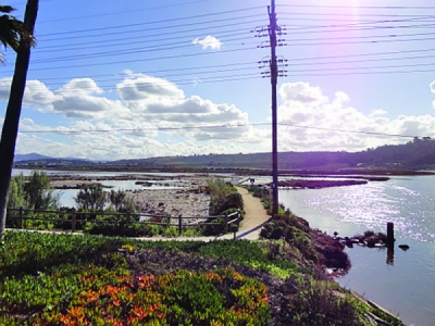
The project involved dredging a large dirt parking lot on the south side of the fairground that bordered the San Dieguito Lagoon. This opened up the tidal flow in 2011, and today the lagoon is full of plant and bird life.
Note that the trail meanders for 2.5 miles east on the north side of the lagoon and under I-5, then turns north towards Flower Hill Mall before heading east towards the Fairbanks Ranch area. However, after crossing under I-5 and turning north, the area is environmentally stressed, with withered plants and none of the benefits of the richness of ocean and fresh water. Thus, the first mile is the best for walking and enjoyment and is the hike described here.
The payoff on this walk is the abundance of migratory and local birds in the lagoon. One day, a long-billed curlew was wading and dining on crustaceans under the watchful eye of a solitary green heron. There were great blue herons and egrets, with terns and bufflehead ducks all sharing a corner of the marsh. In the middle of all of this, a marsh harrier came rumbling through. We even saw an endangered California gnatcatcher flitting about in the coastal sagebrush.
Because this is a restoration project, native plants are abundant, making this a great outdoor classroom for learning native plants. California brittlebush sunflowers were in full bloom, dominating the coastal sage scrub vegetation, as well as pickleweed along the trail’s edge. In this one-mile stretch from the western end of the lagoon to just past I-5, we positively identified over 25 native plants.
The presence of coastal salt marsh plants such as pickleweed (Salicornia pacifica) and saltgrass (Distichlis spicata) indicates that the waters of the lagoon are a mix of fresh and saltwater. Other plants include coastal goldenbush (Isocoma menziesii), cholla cactus (Cylindropuntia fulgida), and California buckwheat (Eriogonum fasciculatum). Native Americans used the buckwheat as a food source as well as a medicinal plant for the treatment of wounds, headaches, and diarrhea.
Along the trail, you will encounter several tall platforms with messy looking piles of twigs. These are osprey nesting boxes. The osprey is unusual among our raptors for its diet of live fish, which it captures by spectacularly diving into the water with its sharp talons extended. Once endangered by the widespread use of DDT, their numbers are rebounding since the pesticide was banned in the United States.
Over 180 different species of birds follow the Pacific Flyway every winter, which makes the lagoon an excellent location for birding. Some other birds that you will see here include the great egret and the long-billed curlew. Several man-made islands have been developed in the lagoon and serve as protected nesting sites for the endangered snowy plover, California least tern, and the Ridgeway’s rail.
SAN DIEGUITO LAGOON (San Dieguito River Park)
Enjoy native plants and shorebirds while exploring the lagoon.

San Dieguito Lagoon map
Driving directions: From I-5, head west on Via De La Valle toward the fairgrounds/race track. Turn left onto Jimmy Durante Drive and continue to the roundabout. Take the 3rd exit onto San Dieguito Drive. Park in the lot on the left side of the street. Note that this is paid parking and it is the only parking in the area. Once parked, walk across the bridge over the San Dieguito River. Look northwest behind the buildings and see the river continue to Dog Beach, the terminus of the river. On the left bank is the River Path that will take you to Dog Beach. Hiking length: 2 miles out-and-back. The trail continues for another 1.5 miles if a longer 5-mile out-and-back hike is desired. Difficulty: Easy, paved path. Another option is to turn left/south out of the parking lot and drive down about ¾ mile to find a well-marked easy trail for kids on the left. Dogs on leashes and mountain bikes allowed.
Source: sandiegoreader.com


