
Posted on September 4, 2018
Faceless bureaucrats are being blamed for mounting silt that has grounded some boats in the “world’s smallest harbor” and rendered a key fuel dock inaccessible for long periods in the busiest charter port on the Oregon coast.
Harbor authorities say it is just a matter of time before much of the port is rendered unusable to hundreds of commercial, charter and private boats that rank it above Yaquina Bay in use by sport fishermen and whale watchers according to state fish and wildlife data.
“It’s really bad,” commented Brady Weidner, the public works director in charge of Depoe Bay harbor, one of two city-owned ports in Oregon. “We used to get dredged every five years like clockwork by the Corps of Engineers, but now we’re not even on their schedule.”
The astonishing notion that an Oregon port could be closed due to neglect by government overseers has alarmed city officials and business operators who say the six-acre harbor supports hundreds of jobs locally and is valued by sport anglers around the Northwest.
Moreover, the port has recently emerged as a leading commercial processor of crab and offbeat seafood products such as urchin and slime eel worth millions of dollars in sales.
“We may be the world’s smallest harbor, but we are the busiest per square-inch,” remarked Weidner, who said Depoe Bay doesn’t rate highly by the criterions of Washington budget.
Those developments were thrown into jeopardy last April when the U.S. Army Corps of Engineers announced its annual dredging list for Oregon’s 15 coastal ports. Typically, the Corps allots about $15 million to scour harbors of silt deposited by rivers and streams that, if allowed to accumulate, would eventually close the harbors to traffic.
Depoe Bay was among two ports, including Tillamook Bay, that were “zeroed-out” on the 2018 list, according to Corps small ports manager Kate Groth.
“Typically in the past, we used to dredge Depoe Bay every five years,” commented Groth, who said the harbor’s pan-flat bottom was last scoured by a vacuum barge in 2014. “But we don’t make the decision. That’s made back in Washington, D.C., by Congress and the OMB (Office of Management and Budget).”
Groth explained how the “metrics” used by federal budget planners to prioritize dredging funds — monies raised by federal taxes and fees on large ocean shippers — are based on “exports and imports.” Those “tonnage” figures, however, ignore Depoe Bay’s leading role in Oregon’s sport fishing and tourist industries.
“Unfortunately, they don’t consider people on charter boats as ‘tonnage,’,” said Groth of the estimated 50,000 anglers and whale watchers that boarded party boats in Lincoln County last year.
Besides tonnage, the number-crunchers take into account “life and safety” factors that elevate lesser ports with breaking bars, such as Siuslaw, Rogue and Coquille, higher on the dredging list than Depoe Bay.
Groth said she advocated for Depoe Bay by providing a “narrative” of the port’s financial impact in her budget proposal, to no avail. According to the state’s Legislative Policy and Research Office, Oregon’s coastal ports support about 15,800 jobs and contribute more than $900 million to Oregon’s gross domestic product.
But the Washington decision makers may be threatening lives by their penny-pinching, anyway. With the boat basin rising, dramatic steps have already been taken to keep the sea lanes safe in the region patrolled by USCG Station Depoe Bay, a 30-member unit that participates in dozens of rescues annually.
“As of right now, we station our boats outside the harbor during anything less than a minus tide,” reported BM1 Andrew Port, a duty officer who drives one of the unit’s two 47-foot motor lifeboats.
While the Coast Guard has its own fuel station, operators in the 25-boat Depoe Bay charter fleet are now at the mercy of the tides to reach the city’s fuel dock. The pier, fed by a pair of 5,000 gallon tanks, sits on an island of silt at low and receding tides.
“it’s a real issue for us to use that fuel dock,” said Loren Goddard, co-owner of Dockside Charters. “After a 12-hour trip, you need to fill up for the next day, and you can’t always wait for high tide. You need that dock available at virtually all times to make your business work.”
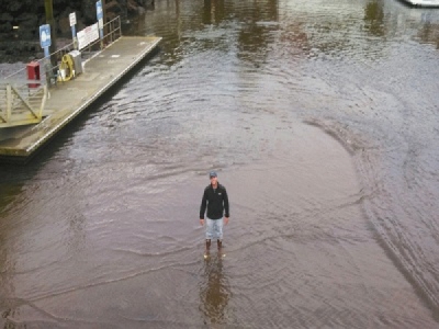
Goddard said he once went aground trying to reach the landlocked pier and had to wait two hours for his 43-foot charter vessel to refloat. The typical depth of the fuel area at mean tide is eight feet, and six feet at low ride — room enough for large boats with a 4.5-foot draught.
But a photograph taken by Goddard of an employee in the middle of the channel shows him walking on mud, not water. Other photos taken by city officials and anglers show the fuel dock beached on a layer of silt, or frustrated boat owners marooned at their slips.
City officials are making plans for a worsening crisis. Dictated by the two-hour change in tide, dock workers are already working longer hours, and may begin to fuel vessels from piers with long hoses.
Meanwhile, U.S. Army Corps of Engineers officials are preparing a 2019 dredging budget that will include nearly $900,000 to dredge Depoe Bay harbor and a silt-retention dam on South Depoe Creek that is overflowing and accelerating the problem. But there is no guarantee the money will come through.
“By 2016 the shoaling levels were what we’d have expected in 2018,” said Jeffrey Henon, a Corps of Engineers spokesman. “Still, Depoe Bay has to compete with the other harbors, and the truth is we don’t know when it will be dredged.”
Source: News Times


