Posted on March 14, 2019
By Heiko Osterchrist, Associate Publisher, DredgeWire
Michael Gerhardt, Vice President of the Dredging Contractors of America, gaveled into session the fourth Pipeline Task Force (PTF) meeting on March 12, 2019, in Washington, DC.
“We are moving forward today with this important group of stakeholders, who all have a vested interest in making sure submerged pipelines are identified before any dredging commences,” said Mr. Gerhardt, who also serves as PTF Director.
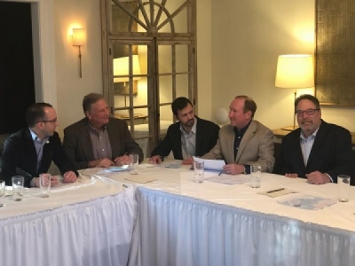
Pictured: PTF members Michael Gerhardt, VP Dredging Contractors of America and PTF Director; Charles Nelson, Right-of-Way Manager, Colonial Pipeline Company; Steven Giambrone, Director, State of Louisiana Pipeline Safety Office; Ed Landgraf, Chairman, Coastal and Marine Operators Pipeline Industry Initiative (CAMO); and Howard Copper, Safety Manager, Dutra Group.
This week’s meeting included a detailed presentation on the role of the National Oceanic and Atmospheric Administration (NOAA) in charting pipelines and existing mapping databases. The Marine Chart Division depicts individual pipeline symbols and pipeline areas on navigational products when as-built documents are received. If a pipeline exists, and NOAA does not possess the as-built information, then the pipeline is uncharted. Further, if there is a change in the status of an existing, charted pipeline, and NOAA did not receive the as-built information associated with the change in status, then the charted pipeline symbol will remain the same.
The PTF also discussed the results of the first “live” dredging project demonstration of submerged pipelines in the Calcasieu River and Pass. Dave McMasters, of Chevron Pipeline Company, presented the demonstration project’s results. Ed Landgraf, of CAMO, and Carl Dickerson, of Mike Hooks, Inc., made significant contributions to the data sets. The goal of the project was to identify and locate submerged pipelines that may not have been marked on an Army Corps of Engineers’ plans and specs.
According to the Army Corps of Engineers, the Calcasieu River is a 68-mile (110km) deep-draft navigation channel in southwest Louisiana. The channel provides deep-draft access to the Port of Lake Charles, the 13th largest port in the USA based on tonnage throughput. The northern boundary (MP 36.0) of the Calcasieu is just south of Interstate-10 highway in Lake Charles; the southern boundary (MP 32.0) extends into the Gulf of Mexico.
The dredging scope, related to the Calcasieu River and Pass, is as follows:
– The Bar Channel requires dredging one or two times per fiscal year;
– The inland pass reaches between mile markers 5.0 and 28.0and requires dredging every other year, which alternate between milemarkers 5.0 – 17, and milemarkers 17.0 – 28.0;
– The upper most of the pass reaches between milemarkers 28.0 and 36.0 and requires dredging every five to eight years.
This demonstration project took place during the preparation of an actual dredging project on the Calcasieu River. Through David McMasters’ leadership, the PTF studied the pipeline crossings in the Calcasieu River. The team compared the coordinates and pipeline ownership information that were provided by the U.S. Army Corps with what is documented in the U.S. Pipeline and Hazardous Materials Safety Administration (PHMSA) database, data from the State of Louisiana Pipeline Safety Office and with other publicly available private sector information. The team found four natural gas pipelines that are not in the Army Corps’ database and nine pipeline inconsistencies.
William P. Doyle, Chairman of the Pipeline Task Force, commented, “I am very pleased with this pipeline task force team. Their work is going to saves lives. These are not meetings for the sake of meetings; we’re getting something done by putting visibility on buried pipelines.”
The task force includes U.S. dredging companies, the U.S. Army Corps of Engineers, the Pipeline & Hazardous Materials Safety Administration (PHMSA), the State of Louisiana Pipeline Safety Division, the Coastal and Marine Operators Pipeline Industry Initiative (CAMO), NOAA and representatives and member companies of the American Petroleum Institute (API), Interstate Natural Gas Association of America (INGAA), and Louisiana Mid-continent Oil & Gas Association.
The dredging workload in U.S. ports and waterways is increasing. Ports and waterways along the East and Gulf Coasts are being dredged deeper and wider to allow transit of post-Panamax vessels. Dredging deeper calls for the utmost care and understanding of the pipelines buried in these waterways. The U.S. dredging industry has responded by setting up a task force of stakeholders to identify where pipelines are located before a dredging project commences and to prevent potential loss of life, injury, environmental pollution, and destruction of assets.


