
Posted on January 25, 2018
By Peter Jensen, Idaho Mountain Express
The Blaine County commissioners don’t want another baseline study of the Big Wood River.
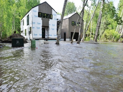
In the wake of last spring’s destructive flooding, the commissioners met with the U.S. Army Corps of Engineers last Thursday and agreed it was time for action. Numerous studies of the river have been completed in the past 25 years.
But what should be done? Which portions of the river need the most help? Which projects should take priority, and which stream-alteration projects should be considered unacceptable? How much will it cost, and who pays?
The county wants to work with the Army Corps, the public and other partners to answer those questions. The subject was too sprawling to tackle in a two-hour meeting Thursday, so the county will host a follow-up meeting the week of Jan. 29 to develop a scope of work with the Army Corps.
The Army Corps has been assisting the county since widespread flooding last spring. The federal agency has offered to help plan a response to the flooding under a program called Section 22 (of the federal Water Resources Development Act of 1974). Blaine County has paid $10,000 to kick-start those efforts, and the Army Corps has also chipped in $10,000.
The county wants to develop a project list and a management plan for the river, which would be based on past studies of the river that evaluated its deteriorating condition.
Commissioner Larry Schoen said he wants to upend the county’s standard practice of responding to flood damage. Typically, a homeowner or a consultant applies for a stream-alteration permit.
That triggers a review process, and application of county standards. One of those standards is to ensure that the work will not result in a rise in river flow. If the standards are met, the permit can be granted and county staff moves on to the next project.
Despite those standards being met, Schoen said, alteration of the riverbanks has fueled deterioration in other ways.
“We know from experience that there are other things that will cause adverse impacts,” he said in an interview Monday. “What we don’t need from the Army Corps is another baseline study.”
He favors a more holistic approach. With the Army Corps’ help, Schoen said, the county can bore down to a reach-by-reach level of detail within the river. He wants to understand the river’s migration corridor, which is where the channel attempts to meander back and forth.
With a science-based approach, Schoen said, the county can assess what the potential for flood impact is in those channels, as well as habitat restoration or protection.
The county can then develop a set of practices related to flood protection and habitat protection or restoration. In those reaches, a hardscape or manmade structure might not be acceptable.
On the other hand, an engineered log structure to protect part of the riverbank might be acceptable, Schoen said. He also suggested that levee removal could be possible in some sections.
“We need a better regulatory framework,” he said. “We have begun to push back and say no to some of these projects.”
The University of Idaho’s Center for Ecohydraulics Research has also offered to help, though it’s uncertain if the county would contract with the organization. The center is one of several consultants the county will consider hiring.
Professor Andy Tranmer spoke during Thursday’s hearing, and said he could help develop a computer model that would help the county with long-term planning and decision making. The model would demonstrate how changes to the river in one stretch—such as bank erosion and sediment deposition—influence other sections.
During Thursday’s meeting, County Engineer Jeff Loomis said the river’s flood maps could be improved. He said a watershed-wide planning council would help.
“We always go into these things as a rudderless ship,” Loomis said. “It’s really easy to get a stream-alteration permit when it’s an emergency and properties are threatened. You’re going to have to get private property owners involved. The lines on the maps are super important.”
Kristine Hilt, the county’s floodplain manager, said she is working to update the maps of the floodplain and the floodway. The county paid to do Lidar mapping during the flooding, which is a surveying technique that uses laser lighting to create high-resolution maps.
Hilt said the flood maps created by FEMA for the National Flood Insurance Program are unreliable. Schoen said those maps can be accurate in some places, and inaccurate in others. Efforts to revamp the maps are separate from the Army Corps’ assistance.
“We enforce to those lines,” Hilt said of the maps. “We saw an unprecedented amount of water come through the watershed. We’re in the process of getting new maps. So much of what [FEMA is] doing is not represented. They’re completely useless in some areas.”
Commissioner Jacob Greenberg said he supports the idea of a watershed council. The county has jurisdiction over the unincorporated area, but the cities of Ketchum, Hailey and Bellevue also maintain jurisdiction over the riverbanks.
Greenberg said zoning and land-use issues will have to be addressed.
“It’s problematic when you have a total reach approach, but you don’t have control of the total reach,” he said.
He asked Army Corps Project Manager Tatton Suter how long the agency’s planning process could take. Suter said the Section 22 work could be wrapped up within a year.
Tranmer said projects will take much longer. He urged the county to include long-term monitoring of any work done on the Big Wood River.
“There should be a piece of your strategy dedicated to monitoring,” he said. “This is something that’s going to take 15 to 20 years. Just keep in mind the long-term perspective.”
Source: Idaho Mountain Express


