
Posted on May 28, 2020
Laser-based remote sensing could have big potential in the maritime domain. But what is LADAR, who’s it for and what are the key benefits?
“Our mission is to be the world leader in innovative maritime sensor products that enhance the safety and security of shipping and all manner of offshore activity,” says Ladar Ltd (LDR) principal Sverre Dokken.
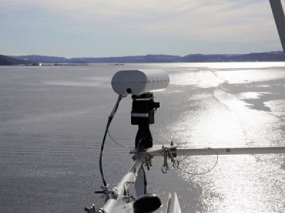
Essentially a laser-based navigational aid, LADAR (Laser Detection and Ranging) combines long-distance object detection with high-accuracy measurement, giving users a full 2D/3D/4D (3D plus time) perspective for optimal maritime awareness. The laser pulse scans a specific area or target with over 100 readings per second. Its water-penetrating capabilities enable very high-resolution detection of objects in the surface layer up to approximately one nautical mile (1.85km) distant and up to 10m deep in ideal conditions. “Objects” can be anything from a person, floating container, icebergs, whales, or small craft to environmental factors such as waves or pollution.
SURFACE LAYER SPECIFIC
“The system’s proven capability to detect, characterize, classify and track various surface-layer objects in real-time make it suitable for a wide variety of applications,” says Dokken.
The modular design incorporates unique technologies such as laser diodes together with optical camera, gyros, optional AIS, and/or radar and sonar feeds to produce a comprehensive analysis of the ocean surface layer ahead of a vessel.
“The system overlaps many existing ship radar functions with added benefits, high-speed operation and no latency,” says Dokken. It can be configured to different light bandwidths as required.
According to Dokken, LADAR outperforms both radar and sonar through its ability to detect both smaller and larger objects in the surface layer. Sub-metre resolution at close and long range and 1000-times better resolution in azimuth and elevation than both radar and sonar also enable detection of very small objects. The system is independent of speed meaning it can be used on high-speed vessels, while it can also be mounted on any kind of stationary platform.
MACHINE LEARNING
Data is visualized on an intuitive, customizable graphical user interface (GUI) enabling seamless transition from above-surface, through-surface and below-surface observations. Machine learning helps to continuously improve detection and classification capabilities. Users can also experience the “live” environment using Virtual and Augmented Reality (VR/AR).
Data feedback can optionally activate functions such as safe re-routing around navigational hazards, wave spectrum and ocean current observations, charting of marine plastic pollution, uncharted reefs, shoals, moving sand-banks, and so on.
“All this makes LADAR the only cost-efficient sub-surface tool that can be tailored to many maritime and offshore applications,” Dokken concludes.
Outside of the clear Search and Rescue potential, the system has other potential maritime benefits. “Our research indicates it can increase safety with a potential 50% reduction in navigational risk. That means fewer dry-dock visits due to accidents and collisions, reduced costs and extended vessel lifetime,” he says.
LADAR can also plug the sensor gap with large amounts of situational data as the industry moves to autonomous operations and e-navigation. LDR is also working on matching the system with drone technology.
“We’re convinced the generalization of this technology will see new applications still unknown to us,” Dokken says. “But right now, there are no other laser sensor solutions in the market with the kind of performance our system offers. Whatever alternatives there are have less range, are bigger and less adaptable. They’re also three or more times the price.”
LDR has conducted trials on board the cruise ferry Color Magic along its route between Oslo and Kiel, as well as proving its use in fish inventory assessment, bathymetric/sea floor mapping by aircraft and floating mine detection for a navy.
The company currently has LOIs in place with the likes of Team Tankers Management, Hurtigbåtforbundet HRF, The Fjords, GOTA Ship Management, Hargun Havfiske, Barents Nord, the Port of Rotterdam and Grand Large Yachting.
By Jake Frith
Source: Maritime Journal


