Posted on March 18, 2020
SUNSET BEACH – The lingering question of where Sunset Beach will put beach-suitable sand dredged from surrounding waterways has prompted the withdraw of the town’s federal permit application.
The U.S. Army Corps of Engineers has withdrawn the town’s application seeking to dredge roughly 3 miles of waterway and place beach-compatible sand on a little more than 8 acres of oceanfront.
The decision to pull the permit application was made after the town notified the Corps it was looking for a new site on which to place the sand, Jed Cayton, a public affairs specialist with the Corps’ Wilmington district, said in an email.
“The application was withdrawn in response to information provided to the Corps that proposed placement area for the beach compatible material will change,” Cayton said. “The placement location has not been determined yet and this office was unable to make a permit decision with the incomplete project design.”
He then referred to a letter the Corps sent to the town in January giving the town a rundown of all the information Corps officials needed to make a decision on the permit application.
That letter specifically noted that the placement site is not eroding or in need of additional sand.
Members of the state’s Coastal Resources Commission, or CRC, last month discussed the letter before ultimately casting a split vote to grant a variance to the Coastal Area Management Act, or CAMA, major permit the town was granted, with conditions, last fall.
The CRC’s variance gives the town approval to dredge about 18 acres, including south Jinks Creek, to a depth deeper than the connecting waters along its eastern border.
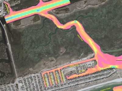
The proposed dredging would help improve navigational access to canals, a bay area and feeder channel through Jinks Creek, which connects Tubbs Inlet to the Atlantic Intracoastal Waterway.
The major permit issued to the town last October authorized the project with the condition that the maximum dredging depth be 2 feet below mean low water, which is consistent with a state rule prohibiting canals and boat basins from being dredged deeper than connecting waters.
The CRC’s variance would allow the project dredge about 10,650 feet of south Jinks Creek, the bay area and the feeder channel, to a depth of no more than 6 feet below mean low water. A series of finger canals would be dredged to 5 feet below mean low water.
Dredging at this depth would ensure the waterways will be navigable at low tide immediately after the project is complete, the town’s project consultant told the CRC last month.
The consultant told the commission that state law dictates beach-compatible sand has to be placed on the downdraft beaches. That means sand has to be placed on Sunset Beach or neighboring Ocean Isle Beach, which declined placing the sand on its ocean shoreline.
Sunset Beach Administrator and Interim Planning Director Hiram Marziano II said the town is in the scoping process of finding a new proposed location in which to place the sand.
“At this point we don’t have a new location yet and we’re looking at other opportunities,” he said Tuesday in a telephone interview. “We’ve been working on another location for the last several months.”
The original proposal was to place an estimated 40,500 cubic yards of beach-compatible sand from south Jinks Creek onto about 1,600 feet of ocean shoreline between Fifth and 12th streets. Noncompatible material, an estimated 48,600 cubic yards, is to be placed in an upland landfill.
In order to place the sand on the beach, the town would have to get easements from private property owners along that stretch of the island.
Marziano said some of those property owners said “flat out” that they would not grant easements, leaving the town in a “our hands are tied” position.
“This is an opportunity for us to resubmit everything,” he said. “This is just part of going through this process.”
When asked if the town has a timeline in which to identify a new sand placement site, Marziano answered, “ASAP,” noting there is not a specific time line.
Sunset Beach will have to submit a new permit application once it finalizes proposed project plans and a disposal area, Cayton said.
“This office will review the submitted documentation and determine if any additional public input is needed based on the proposed changes,” he said.
The town will also have to go back to the state Division of Coastal Management, or DCM, for approval.
“Due to this change, the DCM will be requiring a major modification of the existing permit,” Christy Simmons, the division’s public information officer, said in an email.
Source: coastalreview


