
Posted on May 31, 2018
By Mark Prado, marinij.com
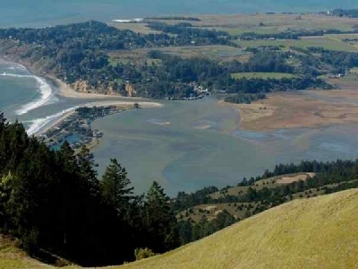
Work to boost environmentally important Bolinas Lagoon and surrounding roads has received an influx of cash from a state agency.
The state’s Coastal Conservancy awarded $285,000 last week to the Marin County Open Space District to prepare construction plans, permit applications and environmental documents for the Bolinas Lagoon Wye Project.
“We are excited that after all these years there is a restoration plan and we are moving forward,” said Karyn Gear, North Coast regional manager for the conservancy and a Mill Valley resident. “This is a first step toward addressing sea-level rise. We have been talking a lot about these types of projects, but not many are moving forward.”
The county also will kick in $275,000 of Measure A funds for road reconfiguration designs. Measure A is a quarter-cent sales tax approved by Marin voters in 2012 for parks and other related uses.
The physical work would cost between $5 million and $10 million, and could be paid for by a variety of state funds and grants. Bids for the work could go out in 2021 and the project could take up to two years to complete.
Dubbed the “North End Wetland Enhancement and Sea Level Rise Adaptation Project,” it aims to protect marshes and roads in the Bolinas Wye area as the sea level rises and the climate changes. The plan is also expected to alleviate chronic flooding of county and state roads in the area that will only get worse as waters rise.
“The Bolinas north end project not only is addressing sea level rise, but will immediately help with road flooding and enhance the lagoon environment,” said Marin Supervisor Dennis Rodoni, who represents the area.
Under the plan, roads in the area would be elevated to take them out of the flood area. Room would be made for streams to be restored to their natural plain and wetlands would be improved to allow them to absorb the rising seas. Without work, more frequent flooding is predicted under both near-term, by 2050, and the long-term in the year 2100.
The project also aims to improve the function of Lewis and Wilkins creeks and would allow Bolinas Lagoon to move and expand.
“The project is the first phase of a larger restoration plan for Bolinas Lagoon’s north end, culminating from 20 years of restoration feasibility studies,” a conservancy report on the issue says.
Home to 23 rare, threatened and endangered animal and plant species and 50,000 migratory birds that come though every year, the lagoon was officially designated a Wetlands of International Importance under the 1971 Ramsar Convention — an international treaty of more than 100 nations — in 1998. It is the only wetlands in the western United States to receive the designation and one of only 17 in the United States.
“Bolinas Lagoon is a special place, a Ramsar designated wetland of international importance,” said Max Korten, director of Marin County Parks. “This project would provide a place for the plants and animals that make their home in the north end of the lagoon to adapt to sea level rise as well as restoring the function of Lewis Gulch Creek, one of the main waterways that feed the lagoon.”
The lagoon provides varied habitat for a unique community of plants and animals. Small fish, which serve commercial fishing industries, thrive in the lagoon. Nearby, thousands of shore and water birds, including brown pelicans and endangered snowy plovers, forage for worms and clams. Only 3 to 4 inches deep in many places, the lagoon’s flat landscape is marked by dried-out tree trunks, scrub brush and muddy loam.
The Marin County Open Space District, the Point Reyes National Seashore, the Golden Gate National Recreation Area, the Greater Farallones National Marine Sanctuary and One TAM are among the groups working on the plan, along with residents of Bolinas and Stinson Beach.
Over the years there have been several plans to “heal” the lagoon. After years of study, the U.S. Army Corps of Engineers suggested a major dredging project as a way to keep water flowing in and out of the lagoon. But the thought of massive excavators digging out the bottom of the lagoon sent chills through the environmental community.
The dredging idea was dropped and in 2008 a plan was adopted by several agencies to restore the health of the lagoon, which is fed by Pacific Ocean tidal action. Formed by the San Andreas Fault, the lagoon bottom dropped as far as 2 feet during the 1906 earthquake.
Source: marinij.com


