
Posted on November 15, 2018
In 2011, Tom Mackland looked out over the water-logged wasteland he called home for 28 years. Dam releases along the Missouri River north of his Crescent, Iowa, farm led to extreme flooding, which destroyed not only his family’s home but caused billions of dollars in damage to other properties and roadways.
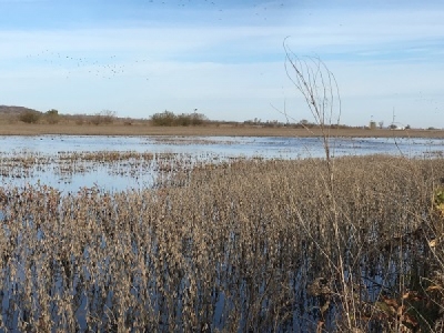
Rushing floodwater washed nearly three decades of memories down the river. Seven years later, nearby fields are flooded yet again.
“It was a great place to live and raise a family,” Mackland says. Today it’s an 800-plus acre farm of which they’ve harvested just under 200 acres. They’re trying to secure a combine with tracks and harvesting in the middle of the night while the ground is frozen to salvage as many of those acres as possible.
Four out of the past 10 years, Mackland has experienced flooding from the fast-rising Missouri River. This year, he’ll only harvest 500 of his 2,000 corn and soybean acres. The closest dam release to his farm is Gavins Point, in Yankton, S.D., a two-hour drive from Mackland’s farm.
For him, and others along the Missouri River, some flooding is inevitable. However, he and other farmers question how much is caused by mismanagement by the U.S. Army Corp of Engineers and misplaced government priorities.
“The 2018 season has been long—the Missouri River has been high all season,” says Jud Kneuvean, U.S. Army Corp of Engineers chief of emergency management for the Kansas City district. “It’s the third highest runoff year in 120 years.”
Runoff required the Corp to release water into the lower basin. In addition, parts of southeastern South Dakota and Northwestern Iowa received significant rainfall this summer and fall—in some areas 20” above normal—a factor for which the Corp cannot control.
While rainfall is in the hands of Mother Nature—not the Corp—some farmers want to see changes in how runoff from snowpack and rain in the upper basin is managed.
“It’s safe to say flood control has gotten worse over the past 10 years—the management of the river has changed, the Master Manual has changed and a lot of habitat projects were built along the river that change the way the river flows in high water events,” says Tom Waters, chairman of the Missouri Levee and Drainage District Association. “We’re seeing more water come to the river faster and there have been no flood control projects in rural areas.”
The Master Manual is a document that serves as a guide to help those with control on the river meet objectives for the river’s system when regulating the six system reservoirs. “Master Manuals for river basins that include more than one Corps Districts are prepared by, or under direct supervision of, Division Commanders,” the Manual explains.
Higher-than-normal snowpack, combined with fast-falling rain caused runoff that meant the Missouri River system quickly reached water levels that demand system releases this year. Even today, certain releases remain open, leaving farmers and business owners downstream with little hope the water will soon recede.
“Due to this year’s high runoff and the water currently being stored in the reservoirs (a flood control function), Gavins Point releases will remain near 58,000 cubic feet per second for the remainder of the navigation season to ensure evacuation of all stored flood waters prior to the 2019 runoff season with much of that occurring before the river freezes over in the norther reaches,” says John Remus, Chief of the U.S. Army Corps of Engineers Missouri River Basin Water Management Division.
According to Kneuvean, that’s about 18,000 CFS higher than normal. The Corp does note flow will be adjusted if downstream conditions merit. It recently proved that when it reduced the Gavins Point release by 12,000 CFS in early Fall until heavy rains in lower parts of the Missouri River basin subsided.
Farmers feel left off the list of priorities when it comes to river management. Water from the river, dams and lakes in northern states is used for recreation and environmental purposes, leaving many farmers wondering where downstream flood control ranks in the list of government priorities.
Just east of Kansas City, Mo., Jeff Nail and his father farm 5,500 acres—the vast majority of which is bottom ground along the Missouri River—and today inaccessible because of flooding. Three hours south of Mackland, he too feels the pain of what he calls “mismanagement” by the U.S. Army Corp of Engineers and governing bodies on the river.
“It seems like the water comes up faster than it did 20 years ago when I started farming,” the Orrick, Mo., farmer says. “I don’t exactly know how they calculate snowmelt, rain and other things, and I realize you can’t stop Mother Nature, but we don’t feel like enough priority is given to flood control.”
The mainstem system’s annual base is 56.1-million-acre feet (MAF) in reservoirs year over year. Anything above that—up to 72.4 MAF feet is available for flood control storage, according to Remus. “After the 2011 flood we looked at if more flood storage would make a difference and it really wouldn’t because we release all the water that comes in. So, whether you have 16 million or 20 million acres of storage we’re still releasing that water,” he adds.
Not everyone sees it that way.
“Not sure how he came to this conclusion, but to me it is the only way to alleviate this ever-increasing problem [adding more flood storage],” Mackland says. “The March 1 level has been required to be 56.1 MAF for as long as I can remember. When they first picked that number, it could have been 50.1 or 61.1 MAF but it wasn’t. It’s a no brainer that having 5 MAF more storage on March 1 of 2018 would have helped tremendously.”
The Corp releases about 25 MAF in an average runoff year. Snowmelt is a contributor to the water that needs to be released. There are two major contributors to snowmelt—one in Montana and the Dakotas that melts from March to April and one in the Mountains that melts from May to July.
“They need to get rid of the water in early spring because they know that snowmelt is coming,” Mackland says. “We’d really like to see a proactive instead of a reactive plan for snowmelt—something they can calculate. Let’s see them release the water as soon as they’re able to get it out of there.”
This year, the Corp started releasing water earlier than years past on March 15 in anticipation of a large snowpack. Mackland recognizes they did better this year than they have in the past by releasing water in early spring rather than waiting until late spring or early summer.
However, river management is influenced by more than just agricultural interest.
In the past 15 years, $774 million was dedicated to fish and birds, compared to $80 million on operation and maintenance for the Missouri River and virtually zero funds were used for construction products, Waters says.
The Missouri River system serves a variety of stakeholders. The Corp serves, ag, ag suppliers, navigation such as barges, recreation, endangered species and flood control for many interests, Kneuvean says.
It’s a careful balance trying to meet the needs of each stakeholder—especially when their needs sometimes oppose each other. No matter what, the Corp has to follow guidelines set by the Flood Control Authorization Act of 1944, the Endangered Species Act, the Clean Water Act and other legal requirements. Much of this is outlined in the Corp’s Master Manual, last revised in 2004 with minor additions and changes in 2006.
Missouri River management leans on levee systems help keep water out of major metropolis areas and some farm districts. “Congress has been looking at levee systems in Kansas City and approved a $453 million budget for levee modifications,” Kneuvean says.
While there are many levees in rural areas, they’re maintained in partnerships between government and private parties. In most cases, levees keep the river from spreading into areas it could cause damage but they also keep water from draining off of fields—presenting another challenge for farmers.
“We used to see the water get out pretty quick, but now it doesn’t have a chance to evacuate,” Nail says. He recently put in two water pumps for about $175,000 and says they’ve paid for themselves in just three years by getting water off of acres he would have otherwise lost.
“There are challenges when it comes to drawing water off of fields,” Kneuvean says. “It’s a double-edged sword—it’s hard to get crops in, then we went through a dry spell and now it’s harvest and they’re flooded again.
“The only way we can drive down risk is by working together, we have to continue to have the dialogue, have open and honest discussion about how we use water resources and what realistically can be done to reduce risk,” he adds.
For farmers, the consequences of flooding can be long-lasting.
“We’re still digging out of a hole of flooding in 2011—we had 2,500 acres destroyed,” Nail says. “We live and die by the river.”
Source: AG WEB


