
Posted on June 23, 2020
Some boaters who travel the St. Lucie River regularly will have smoother sailing likely sometime in 2021.
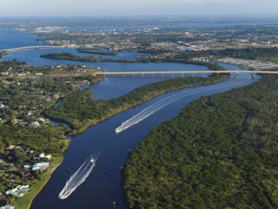
The Army Corps of Engineers Jacksonville District announced Tuesday it has begun the planning process to dredge 15.5 miles of the Okeechobee Waterway from the Crossroads, where the waterway intersects with the Intracoastal Waterway at the Indian River Lagoon, to the base of the St. Lucie Lock & Dam. The entire area to be dredged will be completely within the St. Lucie River’s middle estuary and South Fork.
“Maintaining safe navigation on federal waterways is one of the Corps’ key missions,” said Ashleigh Fountain, Project Manager. “Accumulation of sediment has limited the navigable capacity in the project channel. Removal of the shoaled material to the authorized and previously constructed depths would improve the navigable capacity of the project channel and be safer for boaters.”
The Army Corps of Engineers has prepared a Draft Environmental Assessment and has opened it to public comment. Respondents may comment until July 15, 2020. To review the plan and submit comment, go to https://www.saj.usace.army.mil/OWWCrossroads-StLucie/.
The project has been divided into four sections — Reach I, Reach II, Reach III and Reach IV. Reach I is the area from the Crossroads to just south of Hell’s Gate. Reach II goes from there up into the middle estuary across from Krueger Creek in Stuart. Reach III goes from there, through the two Roosevelt Bridges and FEC Railway Bridge and down to Pendarvis Park in Palm City. Reach IV goes from there, through both bridges in Palm City, under the Turnpike and I-95 bridges to the locks.
The federal channel would be maintained to its authorized dimensions: 8 feet below Mean Low Water, plus 2 feet over depth, by 80 feet in width. Project engineers estimate the need to remove 42,000 cubic yards from the channel within Reach III and 31,000 cubic yards for Reach IV. The removal volumes for Reaches I and II will be located, calculated, and designed at a later time, as funding allows, according to a press release.
Capt. Rocky Carbia who pilots the Safari I party fishing boat daily from Pirates Cove Resort and Marina in the Manatee Pocket in Port Salerno said there is a shoal at the Crossroads that needs to be removed as soon as possible.
“On the easternmost south side of the marked channel at the Crossroads it’s measuring about 5 feet deep at the bottom of low tide,” Carbia said. “The Safari I draws about 4.5 feet of water.”
The draft environmental assessment takes into account endangered and sensitive species of plants, marine wildlife, fish and other organisms found within the area of the planned dredging.
Near Reach I, the following seagrass species can be found:
- Turtle grass
- Shoal grass
- Star grass
- Paddle grass
- Widgeon grass
- Manatee grass
The assessment considers sea turtles, manatees, oysters and even smalltooth sawfish. The Army Corps has determined that none will be adversely affected by the project.
In addition to maintaining a navigable channel, the project has one other primary consideration — where to put the dredged material. Four dredged material management areas have been designated to receive what is dredged up.
Dredged material management area O-7 is 62 acres and is located approximately 2,344 feet west of the St. Lucie Lock and Dam. DMMA O-23 is 31 acres and is located to the south of 1310 NE Business Park Place in Rio, approximately 0.55 miles north of the St. Lucie River shoreline.
Material from the dredged locations will be pumped to the dredged material management areas via pipeline and de-watered with the water returned to the waterway.
The need to dredge the channel was caused in part by Lake Okeechobee discharges. Heavy discharge events in 2005, 2013, 2016, 2017 and 2018 actually filled the South Fork of the St. Lucie River with sludge and silt.
A portion of the draft environmental assessment says:
“…operations of the Central and Southern Florida system, require discharges of large volumes of freshwater to the estuary during intense rainfall events. Along with the freshwater discharges have come much deposits, other sediments and excessively high levels of nutrients including phopshorous and nitrogen. Much has accumulated on estuary bottoms and has covered large areas, impeding penetration of sunlight to the bottom, reducing oxygen levels in the water column, and indirectly causing the disappearance of native seagrass and oyster beds.”
Source: tcpalm


