
Posted on December 4, 2017
The St. Louis district of the U.S. Army Corps of Engineers is seeking public input on a proposed project to rehabilitate Crains Island for the purpose of restoring aquatic and wetland habitats on the 553-acre refuge.
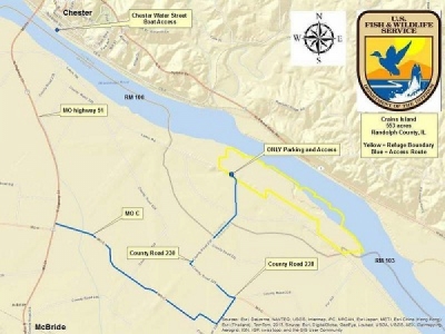
Crains Island is located on the Missouri side of Randolph County on the right downstream bank along the Mississippi River between mile markers 103.5 and 105.5. It is about four miles southeast of Chester and across the river from Knight Hawk Coal’s Lone Eagle coal dock.
“Human activity over the past two centuries within the Middle Mississippi River (MMR) basin, floodplain and channel has altered the hydrology and biotic communities historically present in the Project area,” the Corps of Engineers wrote in an Upper Mississippi Restoration Feasibility Report. “These alterations have reduced the diversity and quality of aquatic flowing side channels, which are limited in the region, floodplain forest habitat that has severely declined since settlement, and wetland habitat, which has been reduced and continues to degrade.”
The objectives of the restoration project are as follows and stated by the report:
– Increase connected aquatic side channel habitat with depth diversity for enhanced fisheries habitat benefits.
– Restore wetland ecosystem resources as measured in acres.
– Increase acreage and promote fine sediment deposition in the project area as measured in acres.
– Restore floodplain forest communities as measured in acres.
The restoration plan includes excavation of side channels from the Mississippi River to the island, a sediment deflection berm and reforestation throughout the whole refuge. The U.S. Fish and Wildlife Service is the federal sponsor of the project.
“Existing side channel habitat on Crains Island is generally shallow, turbid and has limited connectivity with the main channel, which are important habitat characteristics required for functional year-round aquatic habitat,” the report states. “Without action, the existing side channel habitat would continue to decline, impacting the survival and recruitment of riverine fish species.”
The report explains that severe flood events on the river during the past 35 years have contributed to the buildup of sediment and wood debris on the island, resulting in a rapid conversion of water cover to land cover in areas of the refuge.
“The area is dominated by soft woods such as silver maple and cottonwood and the missing component is the some of the hard woods like pecan and oak,” said Brian Markert, project development branch manager. “A lot of those species were removed in the settlement era in the steamboat days.”
Deforestation along the river is believed to be a key contributor to the Mississippi River changing course after the flood of 1881, as hard timber along the riverbank made for easily accessible fuel and construction materials.
Markert is hoping this project restores some of those species that were lost to history.
“What we look at is historic documents, records and surveys,” Markert said. “The 1800s had some pretty detailed surveys of the river and the surveyors would often write what type of species they encountered.”
According to the book “The History of Randolph County Including Old Kaskaskia Island,” by E.J. Montague in 1859 and reprinted in 1948, John Crain and his seven sons came to the area between 1800 and 1802 and settled along Marys River.
The family, according to the book, were “leading men” in settling the country around the mouth of Marys River and the island that would eventually bear the Crain name. John Crain lived on the island for many years and died there in 1850.
Markert emphasized that the restoration project will not impact commercial navigation on the river or the federal levee system, which is vital for flood control. He stated that once construction begins, earthwork would take place during the first year or two, followed by reforestation in subsequent years.
“I would anticipate that this project, if we were to receive historic, average funding, would take between four to five years to complete,” he said. “The majority of the construction usually takes place between two to three years.”
The Army Corps of Engineers has scheduled a public open house on the draft report for December 7 from 5 p.m. to 7 p.m. at the Perry Park Center Meeting Room in Perryville. Members of the public can also submit comments by calling Ben McGuire at 314-331-8478 or emailing Benjamin.M.McGuire@usace.army.mil.
Those seeking more information can visit www.mvr.usace.army.mil/Missions/Environmental-Prot…
“Long-term, we’re hoping to restore something that’s sustainable and resembles the components of the Mississippi River habitats that have been lost or degraded over time,” Markert said.
Source: Herald Tribune


