
Posted on February 17, 2020
Originally posted on 10/3/2019
Arc Surveying & Mapping, Inc., Jacksonville, Florida presents game changing geophysical surveys and user friendly Demco Aquares 3D Subsurface Scanner Technology. Visualize the subsurface in a manner never before possible.
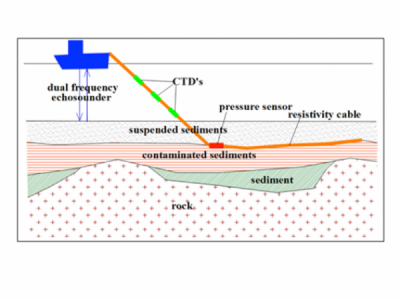
The Aquares technology, developed by Demco NV, has been used worldwide and by the US Army Corps of Engineers in previous years as a marine geophysical method to determine the feasibility of future port and channel deepening projects in New York, Philadelphia, Tampa, Jacksonville and Miami, Florida. During 2017 Arc Surveying & Mapping, Inc became interested in this technology and successfully test edit comparing the results with core borings at several ports and at contaminated sediment locations in Florida. The Aquares technology has the capability to combine subsurface geological survey results with borehole and SPT data in a real-world 4D model that can be visualized in platforms such as Google Earth.
Recent developments
More recently, a new tool was developed allowing the users to visualize Aquares information in 3D together with borehole and geotechnical information. This tool is named the Aquares 3D Scanner.
The Aquares 3D Scanner allows, with a simple mouse click, to generate vertical and horizontal geophysical sections on the fly in a 3D setting containing boreholes and geotechnical information to correlate it with. It’s interaction with geophysical and geotechnical databases allows to obtain quantitative information such as vertical and horizontal geographic position, resistivity values, lithologies, borelogs just by pointing with the mouse to any relevant object or point of interest. The real-time interaction with database information makes the Aquares 3D Scanner an extremely useful visual tool for design and engineering purposes.

Think of the Aquares 3D Scanneras being similar to a medical PET (Positron-Emission-Tomography) scan. A PET scan provides a visual multidimensional colored image model of the inside workings of the human body while the Aquares3D Scanner provides in real-time visual georeferenced colored images of varying subsurface structures combining geophysical with geotechnical information.
This technology is an absolute game changer on the market. Major companies (BGC Engineering, Esri, Oracle, Autodesk, Microsoft) have been showing their interest and the main USACE office in Washington is talking about making it a standard.
New applications
Until recently Aquares technology was used locally on very specific projects, such as identifying contaminated sediments, sand deposits or dredging projects. However, the possibility to visualize combinations of geophysical and technical information by interacting in real-time with databases opens the way to a completely new market in the field of Asset Management.
Many ports or waterway institutions have large amounts of information stored in telephone book size reports with geological, geophysical and geotechnical information. This information is not always easily accessible and therefore often gets lost or is never used. For such a port or waterwayinstitution a database combining all this information linked together in an Aquares 4D model to be visualized in a user-friendly way using the Aquares 3D Scanner may be considered an ‘Asset’ serving large number of projects in that port or waterway.
It is our opinion that ports should consider a complete geophysical survey of their facility incorporating historical geotechnical reports, borings etc., all converted to the appropriate horizontal and vertical datums. The port model will be provided with the 3D Scanner technology and will be available throughout the upcoming years for engineering, planning and design of future expansion projects.
See link for video:
https://youtu.be/668oHI5PbXU
For more information contact John Sawyer at (904) 384 8377 or
jsawyer@arcsurveyors.com


