
Posted on June 21, 2018
ArcDMC Sediment Solutions, LLC successfully completed an innovative geophysical survey of muck sediment in the Indian River Lagoon, Florida precisely locating the aerial extent and depth of muck (over historic sediment) to accurately determine volumes for cost-effective surgical dredging.
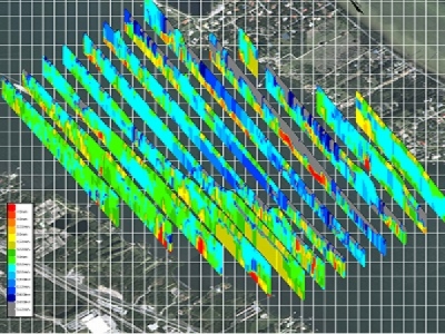
The goal of the survey was to demonstrate that ArcDMC’s resistivity survey method followed by vibracore sampling and testing would be an effective approach in determining the presence and precise quantities of muck, especially contaminated muck, in the Indian River Lagoon (IRL).
Traditional methods of muck removal using a prescribed dredge-template can result in the unnecessary excavation of large volumes of uncontaminated sediment. ArcDMC’s methods are designed to significantly impact restoration-dredging costs. The resistivity surveying and mapping done by ArcDMC clearly permits precision dredging, resulting in the removal of target sediments only. This minimizes disturbance to the lagoon bottom and reduces dredged material management costs. ArcDMC’s data shows strong correlations between resistivity muck thickness and the chemical concentrations in the sediment. Further surveying is needed in order to fine tune the methodology and pinpoint areas to be dredged with the utmost level of precision and accuracy.
The IRL is a vast and intricate ecosystem and it is one of the most biologically diverse estuaries in the nation. Throughout the years human activities have compromised the environmental integrity of the IRL by introducing various contaminates into the ecosystem through wastewater discharges and continued stormwater discharges. These contaminants blanket the lagoon bottom in the form of muck. The presence of muck is actively degrading water quality and hindering the IRL’s ability to sustain resources and marine life. The Rockledge Muck Test Survey was successful in illustrating that a precise survey using proven technology to identify contaminated muck areas and quantities within the Indian River Lagoon significantly reduces the costs of dredging necessary to restore the IRL.
Between November 2017 and March 2018, Arc Surveying & Mapping, Inc and ArcDMC performed a “Muck Test Survey” in a 29,500,000-sq. ft. area (677 acres) of the Indian River Lagoon near Rockledge, Florida. The purpose of the survey was to locate both the top of the contaminated muck and its interface with uncontaminated sediments as well as the planimetric extent of muck utilizing advanced geophysical techniques. The survey also provided maps and xyz files to accommodate surgical dredging of the contaminated muck sediments. Previously, Florida Institute of Technology (FIT) attempted to identify contaminated muck in this area through the use of manual probes, performed by students and volunteers pushing 2-inch diameter PVC pipes into the lagoon subsurface to refusal. FIT probe depths indicated muck blanketed most of the test site area and ranged in thickness from 1ft to 5 ft.
Using innovative geophysical techniques and verifying the results with vibracore borings, ArcDMC determined that only one third of the test area contained contaminated muck and computed the quantity to be 630,000 cubic yards. ArcDMC collected sediment samples from the vibracore borings and the chemical analysis of these samples determined that the muck contained much higher levels of nitrogen and phosphorus. These contaminates are resultant from decades of pollution and storm water/sewage runoff. In order to restore the IRL to its former biological stasis this muck must be removed from the lagoon bottom.
The resistivity survey technique will be a valuable tool in facilitating a cost-effective method to identify muck that needs to be removed.
SOURCE: www.arcsurveyors.com


