Posted on September 1, 2016
By Allison Petty, herald-review.com
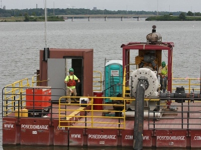
Great Lakes Dredge and Dock crews have made their way into the Sand Creek area, where two small diesel-powered dredges will run 24/7.
The dredges, named the Maggie and the Chris L., are located near the bridges at South Shores Drive and Grove Road. The city’s contractor is also using a modified backhoe, sometimes called a “swamp buggy,” to remove lily pads and other debris in the shallow area.
“They couldn’t maneuver the big dredge in here,” said Jerry Stevens, engineering services coordinator for the city’s Water Management Department. “The bridges are not high enough to get under. They have to get a smaller dredge in here that can navigate the area better.”
Once they’re done, the Sand Creek basin will be about 5 feet deeper, he said. In some areas, the basin is so shallow that the dredge must create a path for crew members to bring materials by boat.
The small dredges in Sand Creek will work simultaneously with the company’s larger dredge, which is further north in Basin 2. There are now a total of four booster stations working to propel the sediment all the way to the 523-acre site in Oakley where it is stored.
So how much smaller are the dredges in Sand Creek? Consider this: The “cutter head,” the steel part that stirs up dirt and debris on the lake bottom, is 65 inches in diameter for the dredge in Basin 2.
Compare that with the Sand Creek dredges, which have 8-inch and 12-inch diameter cutter heads.
Because the smaller dredges are diesel-powered, they’ll make more noise than their electric counterpart. Crews will take decibel readings to ensure that the noise does not exceed city specifications, Stevens said.
The $91 million dredging project began in fall 2014. Workers so far have completed dredging in Basin 1 and the Big Creek area, as well as increasing the capacity of the sediment storage site.
After Basin 3, the crews will continue to basins 3 and 4. The project is expected to increase Lake Decatur’s total capacity by 30 percent, for an additional 52 days of water supply.
The location of the dredges can be viewed by clicking “Lake Decatur Dredge Location Map” on the left-hand side of the city’s website, decaturil.gov.
Source: Herald & Review


